Prepare and Respond to Severe Weather Better with a Complete End-to-end Solution
Since the advent of weather applications for radar following the second World War, engineers and operators have historically encountered a number of major challenges.
From the accuracy of data processing to the maintenance and longevity of radar investments, the need has been clear for improved clutter suppression, automated calibration, maintenance, and remote monitoring.
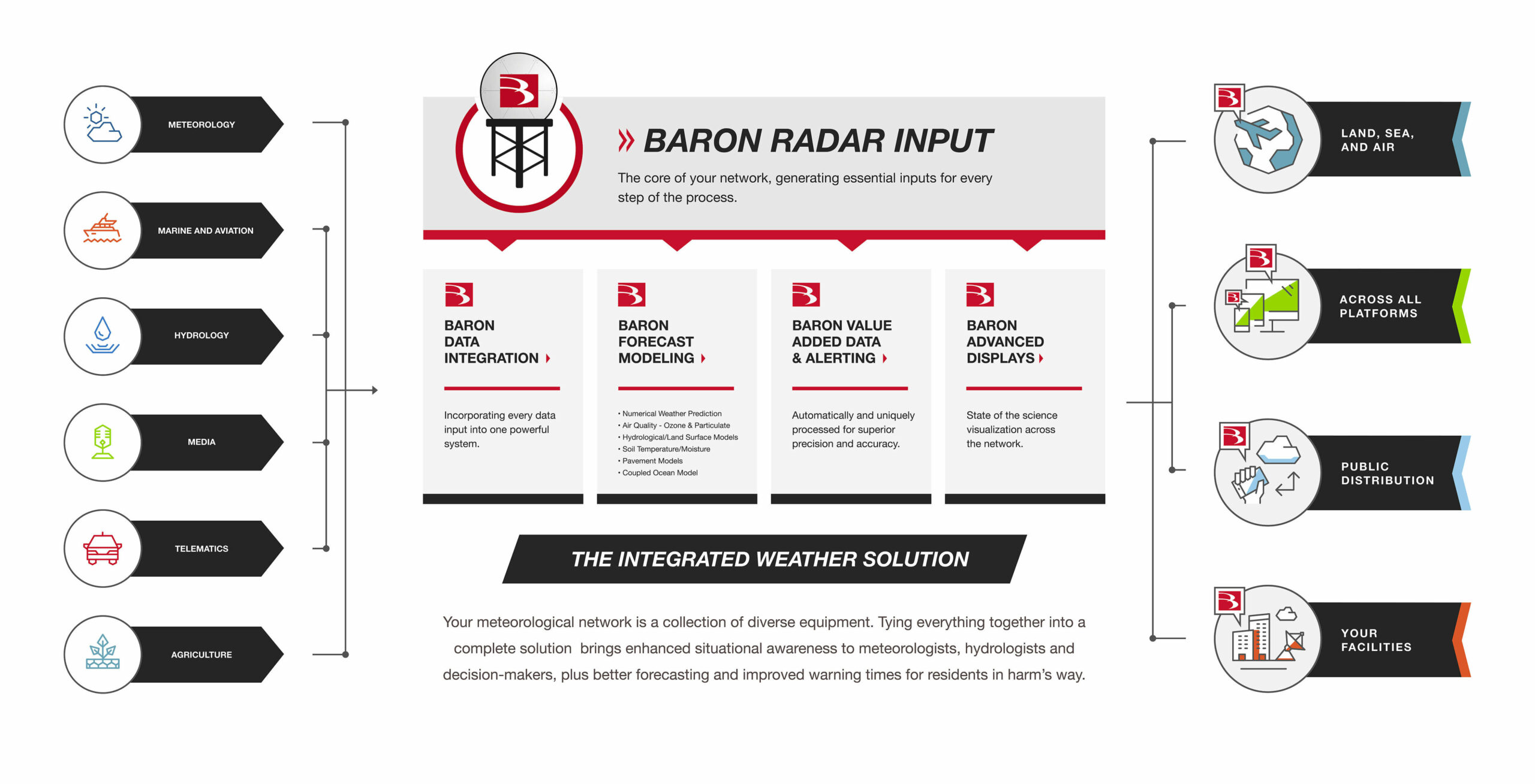
A fully integrated meteorological network (example illustrated below) meets these challenges in several ways. A typical complete solution from Baron incorporates data inputs from a host of sources, enabling network-wide distribution of radar imagery and analysis, generating forecast models for a host of applications, performing radar-derived value-added processing, and more. Each of these solutions can be provided as a standalone system or integrated into the customer’s legacy network using a unique level of integration capability.
Flooding Applications
Hydrologic events like the European floods of 2016 cost billions of Euros in damage and frequently result in the loss of life. In Romania, Baron and its partners have constructed a nationwide network for forecasting and monitoring of destructive waters—from data acquisition and modeling to integration and redistribution—complemented by the detection and integration capabilities implemented during the earlier construction of the country’s integrated meteorological network. Forecast models, weather radar, river gauges, and more inputs are used to generate this information. These systems are collectively tied together to track conditions, providing flooding guidance and early warning for Romanian hydrological and meteorological authorities, at national and sub-basin scales.
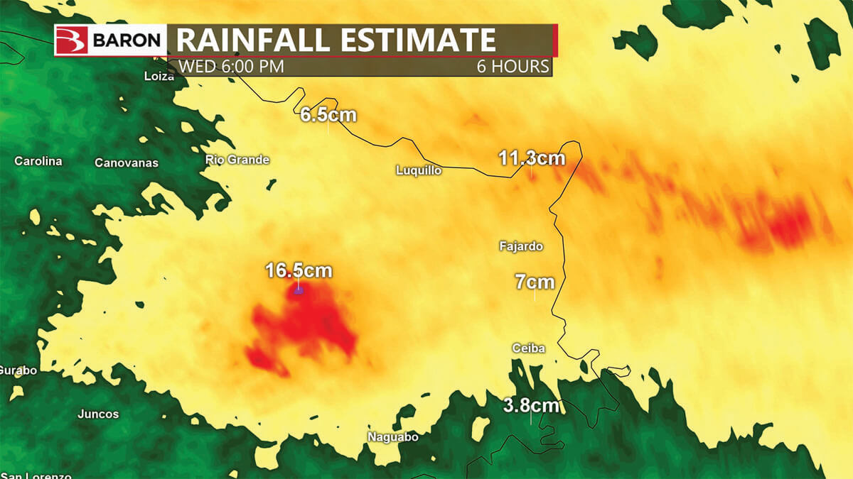
With the NEXRAD program in the United States, Baron data scientists have developed a suite of single-site and composite radar data products for more accurate monitoring of precipitation rates and accumulations. The most recently developed dataset provides meteorologists with accurate radar-derived rain accumulations for the past 1, 3, 6, 12, and 24 hours (Figure 2). Updated every 4 minutes and delivered in 1km resolution, these products have a comprehensive network-wide rainfall composite, using every radar data input available in the network.
Hail Forecasting
An assessment conducted by the European Environment Agency in 2017 found that model-based studies for central Europe show some agreement that hailstorm frequency will increase in the region. That same year, significant hailstorms in Spain, Croatia, and Turkey emphasized the widespread damage these events could cause.
Hail detection has traditionally been performed by monitoring reflectivity spikes within a convective thunderstorm. Dual-polarization technology has enabled significant improvements through raw moments, particularly when value-added processing is applied. In the US, Baron has engineered value-added data products for hail detection and tracking, generated by sampling a storm with dual-polarization radar, in this case a NEXRAD station, at multiple elevations. The resulting volumetric data package is evaluated to automatically identify hail’s non-uniform shape, moderate Correlation Coefficient values, and near-zero Specific Differential Phase.
Detected hail is then depicted on the display workstation, isolated from surrounding rainfall. Additionally, processing can be applied to create a 1-hour composite of dual-pol hail data (Figure 3), allowing meteorologists to track the path of hail, providing enhanced situational awareness, and aiding in post-storm response.
Winter Weather
For winter weather events, such as the 2018 Great Britain and Ireland cold wave, organizations need critical weather intelligence to accurately predict life-threatening winter events, prompting shelter openings, increased public transit, and general weather awareness.
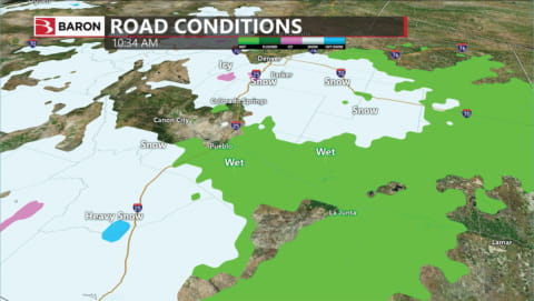
Numerical weather prediction, such as the Baron Model, is essential in projecting the movement and intensity of wintertime temperatures, precipitation, cloud cover, and more. In the US, Baron also produces a unique road weather model (Figure 4), allowing organizations dependent on road travel, such as emergency management and transportation departments, to have greater pre-event information on an event’s likely impact on roadways. This information is typically distributed through a secure web portal, allowing authorized users throughout an organization access to accurate information.
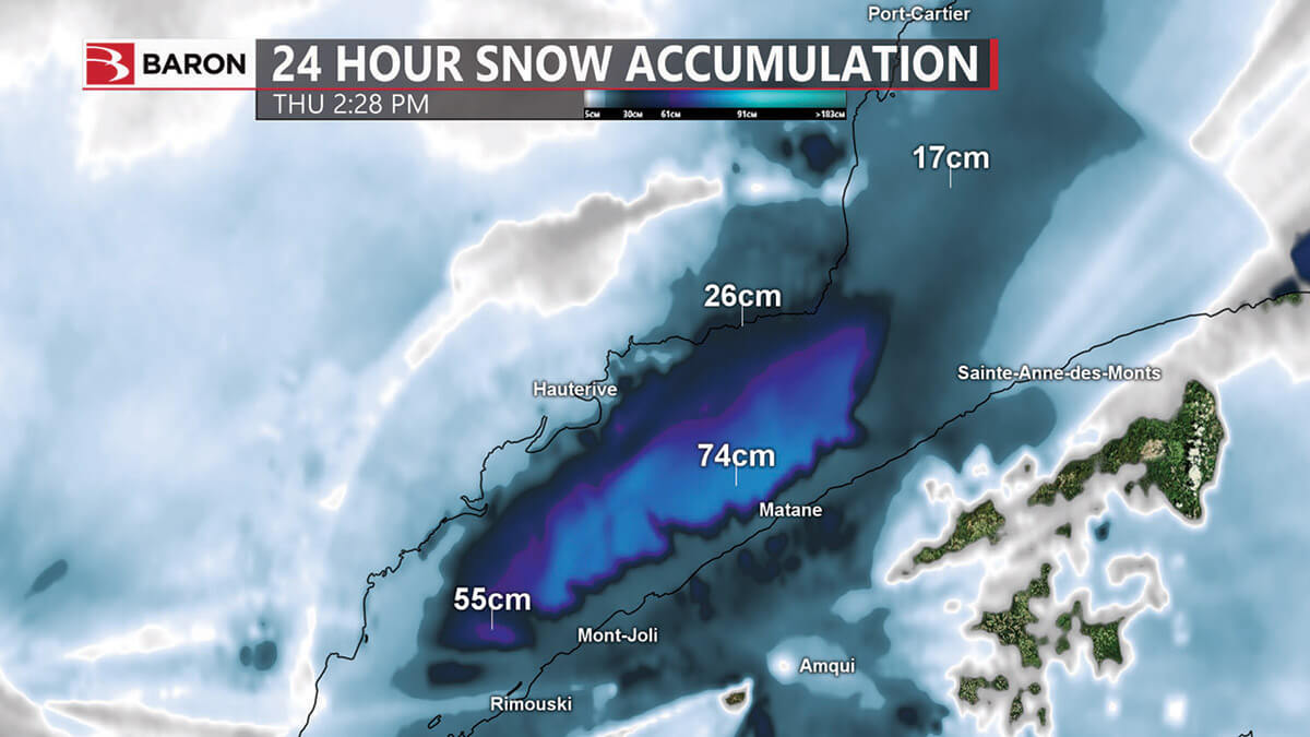
A new suite of nationwide snow accumulation products based on NEXRAD data has recently been made available in the US, as well (Figure 5). Providing 1km resolution and 4-minute update cycles, the wider range of these national-scale products gives forecasters a larger range from which to evaluate winter weather’s impacts throughout their regions of responsibility.
Damaging Winds
A study published in 2014 by researchers from the European Severe Storms Laboratory confirmed that an average of 278 tornadoes and 205 waterspouts occurs annually across Europe. Despite this, only 7 of 39 European weather services have a tornado alerting procedure in place.
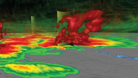
Radar-derived wind shear detection, such as the techniques developed by Baron, automatically identifies rotating winds that can lead to tornadoes, depicting the location of these signatures (Figure 6) via a circular icon and giving the meteorologist instant awareness of an area warranting further manual inspection, typically of velocity and dual-pol products. Another radar-derived product, Baron Shear Rate, displays the speed change rate in wind patterns, helping meteorologists locate areas where tornadic and downburst development may occur.
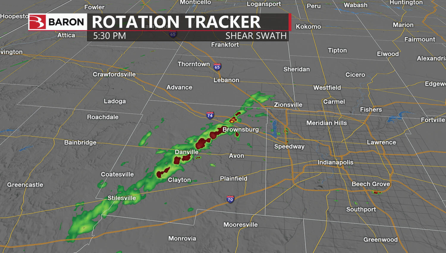
A one-hour composite called Baron Shear Swath (Figure 7) allows forecasters to track the movement of circulating winds throughout the region with extreme accuracy. Additionally, dual-pol radar information is also used in an automated manner to search for suspected tornado debris—trees and structures, for example, thrown aloft by the rotating winds—and indicate the position of any concerning signatures on the map.
Visualization Applications
For visualization, distributed display workstations provide personnel throughout the decision chain with continuous access to the same information. With Baron-provided installations, visualization of these data products and others is achieved through the Baron Lynx display workstation. Single or multiple workstations can be deployed, allowing meteorologists throughout the network to view radar information and perform path casting and advanced analysis using value-added data products, volumetric imagery, and RHI analysis (Figure 8).
.jpg)
The Lynx system may also be used for internal and public-facing weather briefings (Figure 9).
A web-based browser display can also be used for authorized users requiring mobility or those with less meteorological training, making observations and analysis from the network to be distributed throughout the decision-making chain.
Alerting and Distribution Applications
Meteorological organizations globally are challenged to reach the largest possible number of people during critical weather events. Often, this must be achieved using very limited budgets and resources. A tightly integrated met network can help with this challenge by streamlining operations and facilitating outreach both within the network and outside it to the general public.
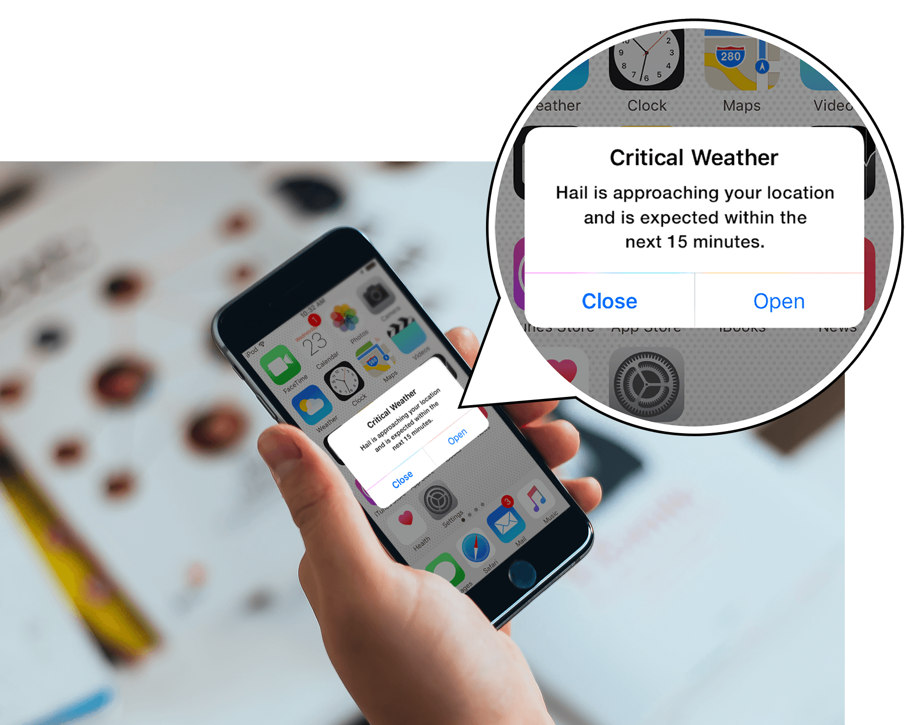
Personnel may opt to use their network to not only predict and detect a dangerous approaching storm or flood situation, for example but leverage the same tools to instantly distribute automated or manual alerts to the affected population. Residents will typically receive these notifications via SMS text message and app-based push notifications.
Automated processes continuously scan for dangerous weather conditions as detected by radar, such as rain, lightning, winter precipitation, hail cores, and wind shear; the latter two alert types use volumetric radar scanning to create storm attribute tables and tracks from which these notifications are issued. Once any of these conditions are detected, alerts are automatically generated and distributed to residents in harm’s way (Figure 10).
Custom push notifications manually entered by authorized officials can also be distributed to weather app users.
Conclusion
From weather prediction and detection to value-added analysis and the timely notification of affected populations, the advantages provided by fully integrated hydrometeorological networks allow organizations to be more efficient and effective in their operations.
Using radar and other sensors to drive models and value-added data products is an important piece of the bigger picture. Still, that picture extends to display, distribution, and alerting, too. For example, in developing situations described in the sections above, all authorized personnel have continuous, immediate access to the information vital to preserving life and property throughout the organization. When accurate information is widely dispersed to the greatest number of people, more informed decisions can be made, and in turn, more lives are saved.
