Alabama SAF-T-Net is a free alerting service dedicated to the state of Alabama by Baron Weather. After the tornados that devasted the state in 2011, the company offered alerting to all citizens in the state. Over the years, the service has centered on mobile apps to offer both alerts and a fully featured weather app.
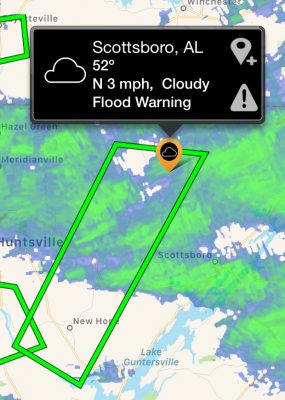
The Alabama SAF-T-Net app alerts you to impending weather danger at locations like home, work, or your children’s school – up to 15 minutes before a storm hits. The app displays current conditions, forecasts, and an easy-to-use weather map with radar, satellite imagery, and more – all year around.
App Features:
- Integrated weather alerts with Baron Tornado Index (BTI) rankings for up to four locations, including your current location.
- Current and forecast conditions based on city, zip code, or your current location.
- Nationwide radar, satellite imagery, temperature, and more.
- User submission of storm photos to local emergency management offices.
- National Hurricane Center (NHC) track forecast cones.
- Three and seven-day forecasts in both quick view and detailed formats.
- National Weather Service, county and storm-based warnings on the map.
You may opt to receive any (or all) of these alert types:
- Special Baron alerts for dangerous storms approaching and “twisting” storms that may cause tornadoes.
- National Weather Service storm-based warnings for tornadoes, severe thunderstorms, and flash floods.
Full-Featured App
Be sure to set up your locations and alerts immediately after downloading the app to continue receiving vital messages. Thank you for being an Alabama SAF-T-Net participant we look forward to continuing to serve you via the app.
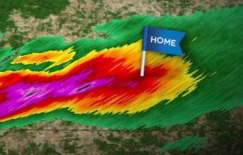
Continuously monitored by a staff of degreed meteorologists, advanced computer processing analyzes the weather 24/7, searching for dangerous conditions such as strong winds, hail, and tornadoes. When severe weather activity is detected in one of your selected or current alert locations, Alabama SAF-T-Net dispatches a notification to your mobile device through an easy-to-use app. You only receive an alert when a location is threatened by hail, high winds, or potential tornadoes.

Storm-based, or “polygon”, warnings are typically issued from the National Weather Service office nearest you. They are more targeted and location-specific than traditional county-wide warnings. Alabama SAF-T-Net notifies you of the following types of storm-based warnings:
- Tornado Warnings: The National Weather Service issues a Tornado Warning when a tornado is indicated by radar, or reported by spotters. You should seek shelter immediately if Alabama SAF-T-Net notifies you that a Tornado Warning has been issued.
- Severe Thunderstorm Warnings: A Severe Thunderstorm Warning is issued when a storm producing hail one inch in diameter or larger and/or winds equal to or exceeding 58 mph is detected. Severe thunderstorms can cause structural damage and produce tornadoes with little to no advance notice, so seek shelter if a warning is issued.
- Flash Flood Warnings: This type of warning is issued when a flash flood is imminent or occurring in the warned area.

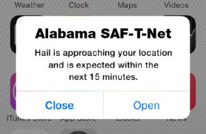
The exclusive technology at work in Alabama SAF-T-Net constantly scans your area, looking for developing weather threats. If a severe storm cell is identified—a hail-producing thunderstorm, for example—the system instantly and automatically dispatches a notification to you (login to your account to opt-in for these messages). These types of alerts encompass weather activity ranging from dangerous storms to specific alerts for hail, rain, snow, and wintry mixes.

The text for this type of message will look like this: SAF-T-Net Weather Alert: Dangerous storm approaching your (location), followed by the storm’s Baron Tornado Index rating.
When you receive a “dangerous storm” message from Alabama SAF-T-Net, it means that a storm capable of these characteristics will be arriving at your registered location(s) within 15 minutes:
- Hail, High damaging winds, Flooding rains
The text for this type of message will look like this: SAF-T-Net Weather Alert: Twisting storm approaching your (location), followed by the storm’s Baron Tornado Index rating.
When you receive an Alabama SAF-T-Net message indicating a dangerous twisting storm is approaching your location(s), it means that a storm containing wind shear, a prime indicator of tornadoes, will be arriving at your registered location(s) within 15 minutes. In addition, you will receive a Baron Tornado Index (BTI) ranking on the likelihood of an actual tornado developing.
The Baron Tornado Index®, or BTI®, provides a simplified 1-10 ranking on the likelihood of a tornado within the storm.
Using sophisticated computer modeling, the patented and patent pending BTI has proven remarkably successful at predicting tornadic supercells, beginning with the Super Tuesday outbreak of February 2008. Combined with the localized power of SAF-T-Net, the result is accurate, targeted weather awareness that’s available nowhere else.

During severe weather, participating Emergency Management officials can send you customized messages with specific information or safety instructions, providing a personalized supplement to Alabama SAF-T-Net’s notifications.
NOTICE: Alabama SAF-T-Net® is discontinuing its existing text and e-mail communication. As of 9/30/2022, the service will only issue notifications through the Alabama SAF-T-Net apps. To continue to receive severe weather notifications from the Alabama SAF-T-Net service, download the Alabama SAF-T-Net app for Android or iOS phones and tablets.
