Scenes from the movies Twister and Wizard of Oz are not as common as they used to be across Tornado Alley. And tornado frequency has more than doubled in the region dubbed as "Dixie Alley" since 1990.
The Shift Quantified
This year's tornado season got off to a near-record start across the South. And data from the Storm Prediction Center (SPC) suggests that the density and frequency of strong tornadoes -- those rated EF2 or greater on the Enhanced Fujita Scale -- have increased in this region over the past 30 years.
Emily Dobbs is a GIS analyst and meteorologist for Baron Weather. She's seen several news stories of this shift in recent years, but many lacked credible scientific proof.
"For tornadoes, the centroid is a more useful statistical measurement. And since this is a single point representing the centermost point of all tracks, it reveals trends over time that are otherwise hard to pick out with other methods," she said.
Emily found the decadal centroid of all strong tornado tracks has shifted 110 miles to the east over the past 30 years.
Credible tornado data is available from the SPC since 1950, but only in the digital age has reporting become more reliable.
"Significant technological advances over the past several decades have resulted in better prediction, tracking, and detection of tornadoes, including Doppler radar, aerial imagery, and social media," Emily adds. "There were likely many tornadoes not recorded in earlier years, which would have skewed the data."
Other Tornado Alley Trends
The geospatial shift of strong tornadoes to the east has been researched extensively since the start of the 21st Century, with many distinguishable characteristics observed. For example, the SPC found that a new maximum of tornado days has evolved over Tennessee, Mississippi, and Alabama since 1986.

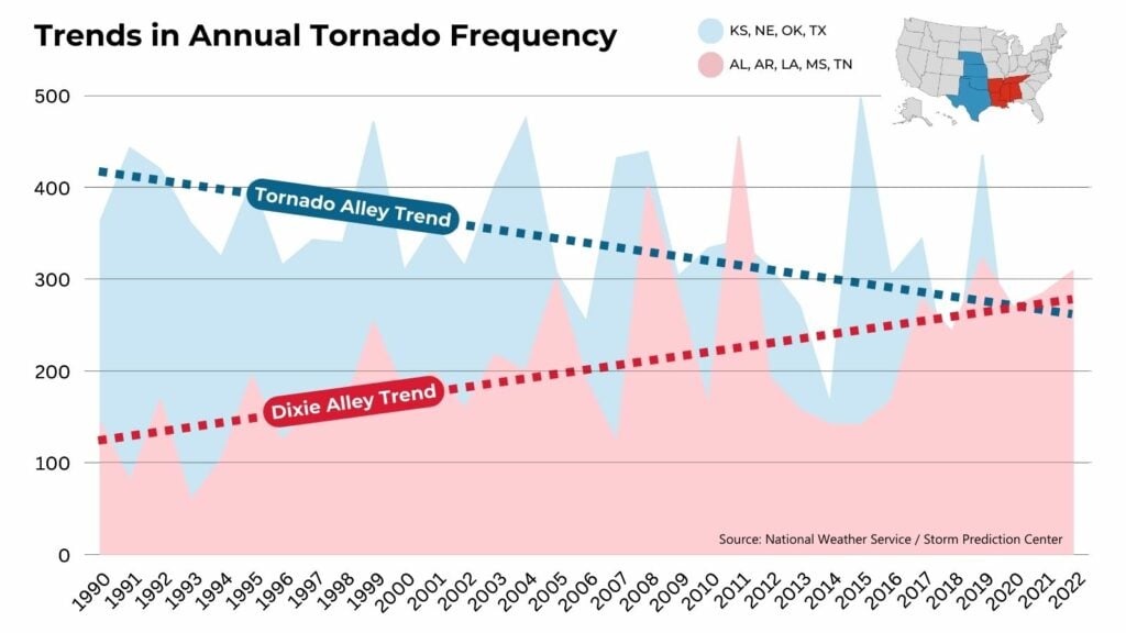
The frequency trend of strong tornadoes has also more than doubled in the southern states of Arkansas, Tennessee, Louisiana, Alabama, and Mississippi (red line) compared to 1990. Meanwhile, there has been a 30% reduction in strong tornadoes across the Great Plains states of Nebraska, Kansas, Oklahoma, and Texas (blue line) during the same time span.
Why "Dixie Alley" is Deadlier
The tornadoes in Dixie Alley also differ temporally and in terms of impact. They occur more often at night, sometimes in the cold season, and tend to be rain-wrapped. The closer proximity to the Gulf of Mexico allows more moisture and instability to be present ahead of the storms in the Deep South. The ability to protect life and property in this region is also heavily compromised by socioeconomic factors such as infrastructure and poverty, according to a risk assessment study in 2020.
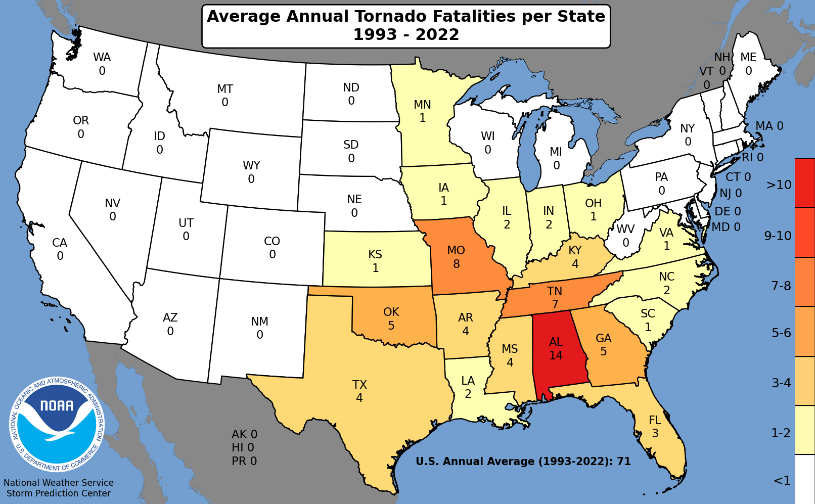
All of these factors make Dixie Alley tornadoes more dangerous, and the numbers speak for themselves. Since 1993, more tornado fatalities have occurred annually in states like Alabama and Tennessee than in Kansas and Oklahoma.
Keeping up with these trends is critical for extreme weather communicators and responders. Our changing climate can influence atmospheric conditions, such as wind shear, moisture, and temperature, that make tornadoes more favorable.
"As we continue making technological advances, it's important to analyze these patterns to identify trends," Emily says. "Time will tell if we continue to see this eastward shift in tornadoes."
Overcoming Reporting Inequities
Baron Weather founded the storm-tracking technology you now see in almost every weather app. The timeline below walks you through three decades of mission-minded innovation from Baron in the interest of public safety with severe thunderstorms.
The Baron Shear Rate product (often referred to by broadcasters as "Spin Detector") is one of the more recent advancements. The simple three-level index eliminates other radar imagery, the so-called "noise," to help public safety officials focus solely on a severe thunderstorm's life-threatening elements. This detection technology can help fill gaps in areas of poor reporting, or late at night when tornadoes are difficult to spot.
Understanding the risk to your life or property is the first step. Taking immediate action on intelligent, reliable data is the lifeline. The exclusive storm-tracking technology mentioned in this story is available to broadcasters, public safety professionals, and app developers through the Baron API or Esri Marketplace. We have  ready to help you want to discuss solutions specific to your needs.
