Baron Weather has developed innovative life-saving weather technology for over 30 years. In that time, the company has become the worldwide leader in critical weather intelligence through its commitment to developing the most effective methods and tools for gathering and disseminating weather data.
Baron’s suite of weather products includes severe weather detection, radars, models and forecasting technology, and alerting systems used by broadcasters, governments, emergency managers, and businesses worldwide. The data and products Baron delivers save lives during extreme weather events and allow companies to make mission-critical decisions when weather impacts their operations.
How Saving Lives Became Our Number One Mission
On November 15, 1989, an F4 tornado tore through Huntsville, Alabama, claiming 23 lives. At the time, Bob Baron was an on-air meteorologist in the Huntsville market. The loss of life that day had a profound impact on Bob.
“Nobody at the weather service or in the broadcast community was able to identify the tornado before it came through a major portion of the city,” Baron recalled.
The weather tracking tools of that time were inadequate, and Bob wanted to change that, so he founded Baron in 1990. The mission was to develop innovative storm-tracking tools to provide better warnings and save lives.
Bob began running the company out of his home while maintaining his broadcasting job. In the beginning, Baron’s staff consisted of Bob, his wife Phylis, two employees, and help from his son Bob Jr. The first project they tackled was delivering radar and lightning data to North Alabama emergency management agencies.
“This was pre-internet,” Bob said. “We set up a network whereby we fed data into the sideband of a local FM station, which other FM stations then picked up to the east and west, and the EMAs downloaded and displayed the data on computer terminals. It was the first time they had a live look at developing weather.”
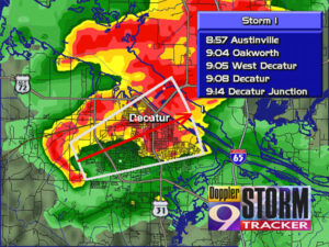
In 1993, Baron released its first broadcast product, OmniWxTrac, an MS-DOS program that allowed broadcasters to track a storm’s speed and direction at street level. OnmiWxTrac featured a vector-based mapping system instead of a raster-based one, which was standard then. The new technology made it possible to zoom in on storms in the air and create individual storm tracks, allowing meteorologists to provide more accurate arrival times for communities in the storm’s path, resulting in better warnings for people to take cover.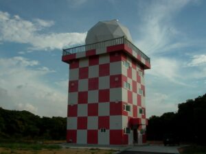
Storm Tracks Using FasTrac

“The integrated ability to zoom in and storm track, defining communities at risk and give an estimated time of arrival was revolutionary,” said Bob.
In the first year on the market, six stations began using OnmiWxTac. By the second year, 20 stations were signed up. While more customers were coming on board, Baron continued to develop better technology. In 1994, Baron introduced FasTrac, its first Windows-based product. FasTrac combined the storm-tracking capabilities of OmniWxTrac with the ability to use a mouse, making it easier for broadcasters to utilize the zooming functionality.
With FasTrac on the market, Baron’s customer base swelled, with 60 stations on board by 1995. Bob left his television job to focus on the company full-time, and the company was well on its way to becoming a worldwide leader in critical weather intelligence. “We were enjoying a rapidly increasing reputation for severe storm tracking,” said Bob.
The World’s Most Sophisticated Radars
To use FasTrac, stations needed a live digital radar, something few had in the mid-’90s. So, Baron jumped into the radar market.
“Do or die,” Bob said about the company’s entry into the radar market. “We started before the NEXRAD network existed, and only 12 (radars) existed in the TV market. When we had sold a half dozen FasTrac systems, we realized we had to get into the radar business to continue.”
Baron’s role as a radar industry leader began by decommissioning National Weather Service (NWS) radars, refurbishing and adding Doppler technology, and then selling them to television stations. The supply of decommissioned NWS radars eventually dried up, and in 1999, Baron began selling its first radars that were wholly designed and built in-house. Not long after that, Baron had the most powerful and accurate radars on the commercial market with the development of megawatt Doppler and dual-polarization (dual-pol) radars. In 2005, Baron was the first to offer dual-pol technology to television stations. Dual-pol radars send both vertical and horizontal pulses, providing forecasters with a clearer picture of the shape and size of systems in the area, making it easier to identify precipitation, including rain, snow, or hail.
In 2007, the most extensive radar network in the United States turned to Baron. The company upgraded all 171 NEXRAD radars to dual-pol and implemented improved calibration routines. The U.S. National Weather Service, the Federal Aviation Administration, and the Department of Defense use NEXRAD radars.
Baron continued to advance radar technology with the development of its Gen3 radar, which featured an entirely new design and innovative remote sensing technologies and could be fully customized to meet customer needs. Through an exclusive agreement with the University of Oklahoma, Gen3 radars feature CLEAN-AP technology. Mountains, buildings, and other structures can cause erroneous hydrometeor detection; the filtering technology reduces inaccurate radar returns, resulting in a cleaner and more precise display of actual weather targets.
A Baron Radar in Taiwan
Baron’s Gen3 radars feature radial-by-radial calibration that sets the standard for keeping radars accurate, consistent, and reliable. By automatically calibrating with every sweep, radial-by-radial radars will calibrate more than 2 million times a year without any human interaction. Historically, radar calibration was laborious and only done once or twice a year.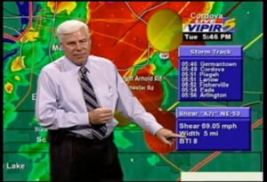
“The Baron Gen3 Radars uniquely provides automatic calibration and CLEAN AP clutter on a bin-by-bin basis, helping to provide incredibly high data quality for the most accurate and precise displays, modeling, and distribution.” Said Bob Baron Jr., who now serves as Vice President and Chief Products Officer.
The Bangladesh Air Force added a Baron Gen3 Dual-Pol radar to its network and 4 Baron Lynx display workstations in 2018. The Air Force also purchased additional radar products designed for aviation, including a numerical weather prediction (NWP) model for the whole country. The critical weather intelligence provided by the radar and integrated modeling allows for better preparation and response when severe weather strikes in Bangladesh.
Baron is the go-to source for radar technology for countries around the globe. Some nations using Baron radars include Paraguay, Indonesia, Taiwan, Azerbaijan, and more.
Technology for all Weather Scenarios
Baron was founded to improve tornado detection technology and ultimately save lives. In the company’s 30 years, it has not only done that but drastically improved forecasting and modeling capabilities for weather like tropical events, hail, flooding, and road conditions.
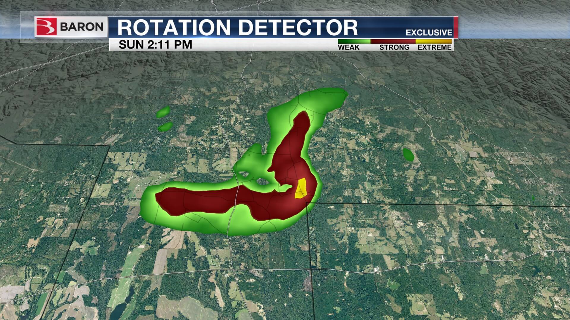
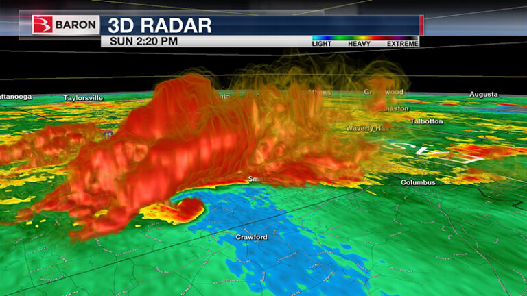
Baron Shear Rate

In 1997, Baron took tornado detection to the next level with the release of VIPIR, a product that introduced 3D radar analysis and revolutionary Shear Markers. Baron was searching for a better way to display rotation in a storm than velocities, which were and could not be composited with other radars. The company began researching shear, which is increasing then decreasing outbound winds butted up against increasing then decreasing inbound winds. The patented technology Baron developed allowed forecasters to see where there was a dangerous twisting of the currents by identifying it with a Shear Marker (a graphic element that visualizes the most hazardous area with a rotating circle or cone).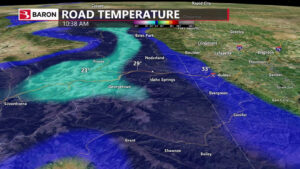
“Not only did the shear product make it easier to depict dangerous areas to the viewer, but it could also be composited with other Radar,” Bob said of the Shear Marker technology. “Since Baron was the only company analyzing every radial of every radar nationally, and since we could patent our process, we could offer an exclusive and patented product to our clients.”
Traditionally, storms have been tracked from their center. In 2000, Baron changed that by developing new algorithms that followed the most severe part of a storm. This allowed forecasters to pinpoint the areas most impacted by the storm and issue more targeted warnings.
The Baron Tornado Index
In 2007, Baron completed the development of its patented Baron Tornado Index (BTI), which set the standard for tornado prediction technology. The BTI ranks the likelihood of a tornado forming in a Baron Severe Weather Track on a scale of 1 to 10. The BTI is built on algorithms that include reflectivity, velocity, VIL data, and more. WMC in Memphis was the first station to use the BTI on air during the 2008 Super Tuesday tornado outbreak.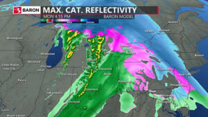
“We handed them the keys to the kingdom, and they hit it out of the ballpark. It performed beautifully,” said Baron Data Services Manager Matt Havin, who played a significant role in developing the BTI. “Every event that used the BTI after that showed us how accurate and powerful the tool is.”
Baron’s forecasting technology moved beyond tornados and severe weather in 2003 with the release of the company’s first weather and air quality model. The company continued developing more models for tropical, hydrological, and road conditions.
Baron’s weather modeling offers unmatched tropical weather forecast accuracy that precisely predicts the path of low systems and the associated precipitation, winds, and cloud cover accompanying the event. Integrating buoy reports, wave heights, water temperature, high-resolution satellite imagery, and satellite-derived radar provides a comprehensive view of the storm. Just one example of the precision of Baron’s tropical forecasting accuracy is Hurricane Sandy in 2012. Baron models could accurately predict the storm’s path as it approached land, pinpointing the landfall location 30 hours ahead.
In the following years, Baron unveiled advancements in its hydrological modeling technology. Baron flood forecasting products incorporate radar data, automated weather sensors, rain gauges, land surface models, numerical weather prediction models, and hydrological models. The resulting data provides critical decision guidance, allowing improved flooding anticipation and better public outreach, and ensures emergency services are dispatched to the most urgent locations. Romania uses Baron technology to manage the nation’s flooding and water management challenges.
Baron’s Road Weather Products
Baron has enhanced the quality of road weather analysis and alerting, using a proprietary integrated land-surface and roadway temperature and condition model that factors geography, surface type, and terrain. The data generated includes where current road conditions are dangerous due to snow, rain, flooding, or ice, where future road conditions will be adverse, and other information valuable for keeping motorists safe. Through Baron’s partnership with XM Radio, road condition data can be delivered directly to drivers in their vehicles so they know of treacherous conditions they may encounter. Companies that manage large fleets, such as Verizon and US Fleet Tracking, rely on Baron road weather data to run their operations efficiently by selecting the best routes when dangerous conditions exist or are forecasted.
“Baron has developed a large portfolio of modeling solutions for weather, hydrology, land surface, roadways, air quality, coupled marine, and agriculture,” said Bob Dreisewerd, Executive Vice President and Chief Development Office at Baron. “The combination of leveraging existing community models and enhancing the models with Baron Intellectual Property has contributed to unparalleled accuracy and numerous value-added products from our modeling solutions.”
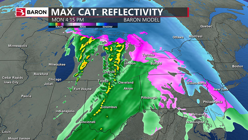
Exclusive Baron Model
Baron set the bar even higher for weather modeling in 2019 with the release of the high-resolution Baron 3k Model. Developed over three years, with model data constantly verified against current conditions to ensure accuracy, the model features many new value-added data products and delivers unmatched precision for daily weather conditions like precipitation, temperature, and cloud cover. The Baron 3k model also offers the most accurate forecasts during critical weather events such as hail, damaging winds, flooding, and winter weather. All forecast data is available in a nationwide 3km display. The high-resolution display allows users to analyze the data down to the street level without losing clarity.
“We can see forecast features in much greater detail,” Bob said of the Baron 3k model. “It is the same as seeing a video in 4k as opposed to standard definition.”
The data generated by Baron’s tornado detection and weather modeling technology is most valuable when communicated to the public. Since its founding, Baron has constantly worked to improve alert procedures and tools. The first advancement came in 1995 with the release of a weather alert crawl for television that featured a live radar display, delivering critical weather information directly into people’s homes. Baron entered the consumer market with the release of its patented geo-located alerting technology, which alerted people (via pagers at the time) only in targeted areas when severe weather was threatening. Baron also developed user-generated custom push notifications, which allow users to determine the weather alerts they want to receive.
In response to the advent of smartphones, Baron developed its Critical Weather App that sent weather alerts directly to users’ mobile devices. The app was used to power Alabama Safe-T-Net, initially launched as an email and text message service. The service featured Baron-generated alerts, including a BTI rating and U.S. National Weather Service warnings. Watches could be issued for current and custom locations, allowing users to know when severe weather threatened them and loved ones in other areas. Alabama Safe-T-Net was free to download.
Mission Critical Weather
As Baron continued to develop innovative weather technology, its product portfolio expanded. Today, Baron delivers actionable weather information in many forms that help companies manage the impact weather will have on their operations. Organizations in various industries, including broadcasting, government, aviation, marine, fleet management, insurance, etc., utilize Baron’s products.
Baron Lynx
In 2008, Baron released Omni, a system with a powerful graphics engine designed to excel in everyday weather scenarios and severe weather situations. Baron’s most recent product, Lynx, still offers unrivaled tough weather tools like storm tracking and hand tracking but also includes exclusive data products, modeling, graphics, and traffic integration needed to create the engaging daily weather content stations demand. Baron has tools that make it easy to maximize reach by sharing weather and traffic stories on the web, social media, and digital platforms.
“It links all our other products together into one seamless package,” Bob said of Baron Lynx. “The real-time storm tracking of FasTrac, the 3-D analysis of VIPIR, and the graphics engine of Omni, into an integrated system with the same mapping.”
In 2003, Baron began venturing outside of the broadcast and radar markets. Baron delivered weather data directly to aircraft, boats and ships, and emergency management agencies through a partnership with XM Radio. In 2013, the company introduced its Weather API. The API allows businesses to seamlessly integrate mission-critical Baron weather data into their apps, websites, and software without needing additional hardware. Delivered through the cloud, the Weather API is scalable, meeting the data demands of large corporations like AT&T and Verizon. The API catalog has hundreds of data products, including over 60 Baron exclusives. The available data includes various historical, current, and forecasted weather data that can be used for everything from flight planning and tracking to verifying insurance claims.

The company that began in Bob Baron’s house is now a global operation with customers on six continents and more than 175 television stations using its technology. The driving force behind Baron’s success and growth has been the development of innovative weather technology that has changed the way dangerous weather is detected and communicated to the public.
“When we first started, there was a straightforward focus: identify significant weather and get the information to those in harm’s way in a clear, understandable way so a life-saving response would occur,” Bob said. “That hasn’t changed in 30 years. It has been amazing to be a part of so many ways of doing so, from radar analysis to modeling, displays, apps, and the world’s most sophisticated radar. I never dreamed 30 years ago Baron would be a leader in so many areas.”
The commitment to saving lives continues at Baron as the company works to push the envelope for weather technology even further moving into the future.
