Key Industries Will Receive Improved Safety Information
Baron, a worldwide leader in weather intelligence and an expert in high-resolution weather and water modeling, has been chosen to provide a state-of-the-art Coupled Atmospheric Water and Ocean (CAWO) modeling system to the Indonesian Agency for Meteorological, Climatological and Geophysics (BMKG).
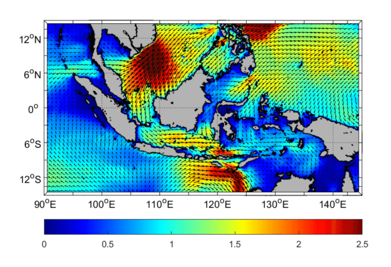
The modeling system is a new emerging technology in “metocean” prediction. The new system will provide unprecedented accuracy for forecasts of the atmosphere above the ocean’s surface, waves at the surface, and ocean currents, ultimately providing life-saving information and protecting property in the island nation.
CAWO is an example of the Baron team leading the way in modeling technology designed to meet the increasing need for more reliable maritime forecasting worldwide. In this project, Baron is a sub-contractor to prime contractor CLS Group, a subsidiary of the French Space Agency, and a Belgium funding company CNP, a global company and pioneer provider of monitoring and surveillance solutions for the Earth. The project will serve as a blueprint for other nations looking to improve the safety of their coastal industries and populations. The Coupled Marine model is a critical component in Indonesia’s Marine Meteorology System (MMS), a program designed to maximize its maritime economy by increasing weather awareness and safety on the seas and shorelines.
CAWO uniquely couples an atmospheric Numerical Weather Prediction (NWP) model with a sea surface wave model and a deep ocean circulation model, providing improved fidelity at the atmosphere/ocean interface. The result is a 10-day forecast for waves, swell, wind, currents, temperature, salinity, and water level. Baron’s technology coupling the three previously distinct modeling components will provide BMKG forecasting capabilities unavailable from other models.
 “By dynamically computing ocean wave characteristics and circulation as they exchange information on the fly with the atmospheric model, precipitation forecasting in the maritime environment improves along with the ability to track and forecast tropical cyclones,” said John McHenry, Chief Scientist at Baron. “It provides more accurate and complete forecast information than a non-coupled model that relies on approximations or static data to represent conditions at the lower or upper model boundaries.”
CAWO will update four times daily and run at a 3km resolution. It will cover all the Indonesian and adjacent maritime areas. This is the first model to produce high-resolution forecasts for such a large domain. The model will be installed on a high-powered computer at BMKG headquarters in Jakarta.

In keeping with Baron’s focus on customer support and training, the Baron team will proactively work with BMKG over several years. During this time, continued evaluation of the model and BMKG’s needs will result in consistent updates and tunings to maximize and validate model accuracy. As part of the MMS1 project, 200 meteorological instruments will be deployed, including drifting buoys, tide gauges, oceanographic floats, and more.
To help BMKG manage the daily operation of CAWO, Baron is providing end-to-end workflow software known as the Real-time Operational Modeling Environment (ROME). ROME includes webpages that display model results and status pages that operations personnel will use to assess the ongoing progress of model runs while enabling real-time troubleshooting when needed. Baron will also provide technical support for the life of the project.