Smoky skylines and air quality alerts have been in the news frequently across the Northeast this summer, coincidently while one of the largest ozone research projects is ongoing.
Unlike smoke or smog, ozone isn't visible to the naked eye, yet its dangers are far-reaching and impactful. That's why scientists rely on high-resolution modeling from Baron to track and predict the chemical formation and movement of this harmful gas.
The "Problem Child" of Pollution
"New York City is our problem child of chronic ozone pollution." Those are the words of Paul Miller, Executive Director of the Northeast States for Coordinated Air Use Management (NESCAUM). The NESCAUM coalition promotes and supports programs to reduce the adverse effects of air pollution and climate change from New Jersey to Maine.
While pollution levels have dropped remarkably in recent years nationwide, the New York City (NYC) metro area continues to violate federal health-based air quality standards. One of NESCAUM's initiatives is the Long Island Sound Tropospheric Ozone Study (LISTOS), a cooperative effort between researchers and government agencies that began in 2017 to investigate ozone formation and its transport downwind from the NYC region.
"The goal is to better understand the chemical and meteorological processes that were leading to this chronic ozone problem," Paul said.
"And the [Baron] model has been fundamental to our success," he adds.
Quality Observations Start with Better Modeling
Identifying the sources and causes of surface ozone is critical to implementing and enforcing mitigation efforts. And the unique geographic features of the Long Island Sound add complexity to this discovery process. The shallow body of water is downwind from the most densely populated region of the United States, bordered by Connecticut to the north, Long Island to the south, and Manhattan to the west.
Xinrong Ren is a physical scientist at NOAA's Air Resources Laboratory, studying the effects of harmful gases in the lowest levels of our atmosphere. He explained why air quality in this region is so harmful and difficult to study.
"We have so many mega cities near this body of water, and it acts like a heat sink for all the pollution coming from New York," Xinrong says. "And then, in the afternoon, as the sun heats the ground more, you get an onshore flow bringing all that pollution emitted earlier back onto land," he adds.
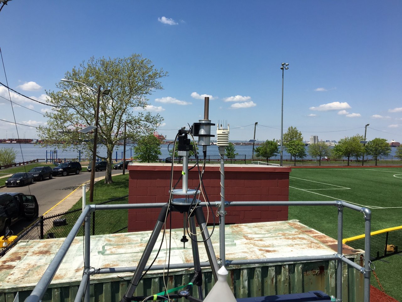
The goal of Xinrong's team is to characterize the emission of air pollutants and greenhouse gases using ground and airborne sensors, which helps them identify how and where the air pollution might have formed. And he says the Baron model helps them to know where and when to deploy their detection equipment effectively.
"We use the model's peak 8-hour ozone maximum for spatial awareness to see the worst conditions," Ren said. "The model really helps us know where to conduct our missions, especially since these gases are hard to see," he adds.
Xinrong used the recent example of smoke-filled skies from the Canadian wildfires to highlight that what you see doesn't always equate to high ozone levels. While it is true that ozone levels this summer were "some of the worst they've seen", the particulate matter from smoke doesn't behave the same as surface ozone pollution, which isn't visible to the naked eye.
15+ Years of Help from Baron
Baron Weather has provided NESCAUM with a customized modeling solution for over 15 years. NOAA has also used Baron's exclusive modeling for other air quality research studies during that timeframe.
"The data we provide gives researchers direct access to detailed forecast conditions in the lowest layers of the atmosphere," said John McHenry, Baron's Chief Scientist for Modeling. "And our models run at two different time horizons and resolutions, a 5-day continental scale and a finer resolution 2-day forecast," he noted.
Baron provides two different models to the LISTOS researchers: 1) a version of the open-source Community Multiscale Air Quality (CMAQ) model from the Environmental Protection Agency (EPA), and 2) an exclusive in-house model that includes the most advanced representation of clouds available in any air quality monitoring system.
"Clouds play a critical role in atmospheric chemistry, and this allows our model to provide a more detailed understanding of the ozone formation processes and evolution," McHenry added.
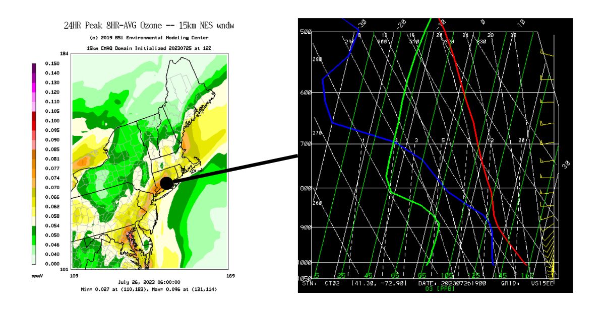
Outputs from the Baron models include animated forecast maps that denote areas likely to exceed the ozone standard (left), along with a unique cross-section view (Skew-T diagram) that uses a green third line (right) to forecast the vertical profile of ozone concentrations.
What's Next for LISTOS
The NESCAUM Long Island study is just one of several being conducted across the country this month by NOAA, NASA, and 21 universities in what is being called an "unprecedented scientific investigation," according to NOAA Administrator Rick Spinrad, PhD. Sources of air pollution will be identified through the deployment of multiple satellites, research aircraft, vehicles, and even instruments in backpacks.
The Environmental Protection Agency (EPA) says that after decades of decline in ground-level ozone and particulate matter, the downward trends have slowed in recent years. The LISTOS effort will help businesses and communities better identify sources of air pollution and how their plumes behave, all with the goal of improving urban and regional air quality forecasts.
"Our mission is to better understand the chemical and meteorological processes that are leading to this chronic ozone problem downwind of New York," Paul said.
The findings of this study will be shared with state and local environmental officials to help them make better decisions that will, in turn, help reduce air pollution in the greater New York City area.
