Former National Hurricane Center Director Ken Graham often says there is no “just a” category with hurricanes.
He’s referring to the misnomer that a storm won’t cause damage or harm if it's not a hurricane. The same could even be said about a yet-to-be-named tropical disturbance.
In early June 2022, a tropical wave moved across South Florida and produced “major” flooding from Naples to West Palm Beach, including over a foot of rain in the greater Miami metro area.
Relentless bands of heavy rain turned streets into ponds and rivers in downtown Miami, and dozens of residents had to abandon their cars in the floodwaters.
Tornadoes were also reported as the system's circulation moved across the peninsula. Winds also gusted to tropical storm strength and caused minor damage.
A tropical storm may not get the attention a hurricane does. Still, emergency managers and insurance adjusters know they can cause damage or even be life-threatening if residents and business owners must prepare adequately.
Assess Your Flood Risk 48 Hours in Advance
The most significant hazard from a tropical storm is flash flooding. The disorganized nature of these storms can make it difficult to pinpoint where the heaviest rain may fall. And it’s often not near the center of the storm. A high-resolution forecast model can help.
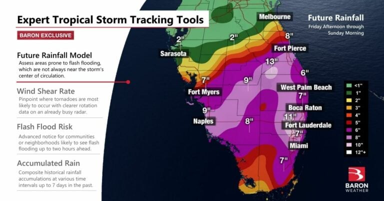
When a tropical storm is in its formative stage or weak, it often moves much slower than a hurricane. As a result, rainfall totals can sometimes be more significant than what a storm produces, but usually in a more localized way.
Detect Rotation for Possible Tornadoes
The radar can sometimes be full of greens, yellows, and reds as tropical storms come ashore. Embedded in those rain bands might be areas of rotation that quickly spawn a tornado. Using an advanced data product, such as one that only shows rotating winds, provides a clearer picture of where to watch and respond.
The Baron Shear Rate (often referred to as "Spin Detector") uses advanced algorithms that allow your team to focus specifically on the threat of a tornado.
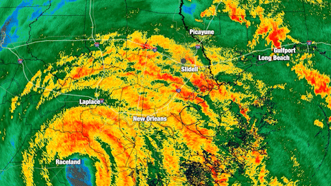
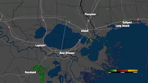
The comparison above was captured during a hurricane moving ashore in Louisiana, and the same clarity can be achieved when using this product for a tropical storm. Notice the difference between a standard radar view (left) and one that offers clarity solely on the rotating part of an outer rainband (right).
Get Advanced Notice of Imminent Flash Flooding
Flash flooding is one of the top weather-related killers in the world. This freshwater flooding has been responsible for more than half the deaths from tropical storms or hurricanes in the U.S. over the past 30 years.
Baron has a newly derived real-time risk dataset that can provide accurate and advanced notice down to the street level where a life-threatening event is likely to occur. The snapshot below illustrates the detail the product can deliver on where flash flooding is most likely within a two-hour window.
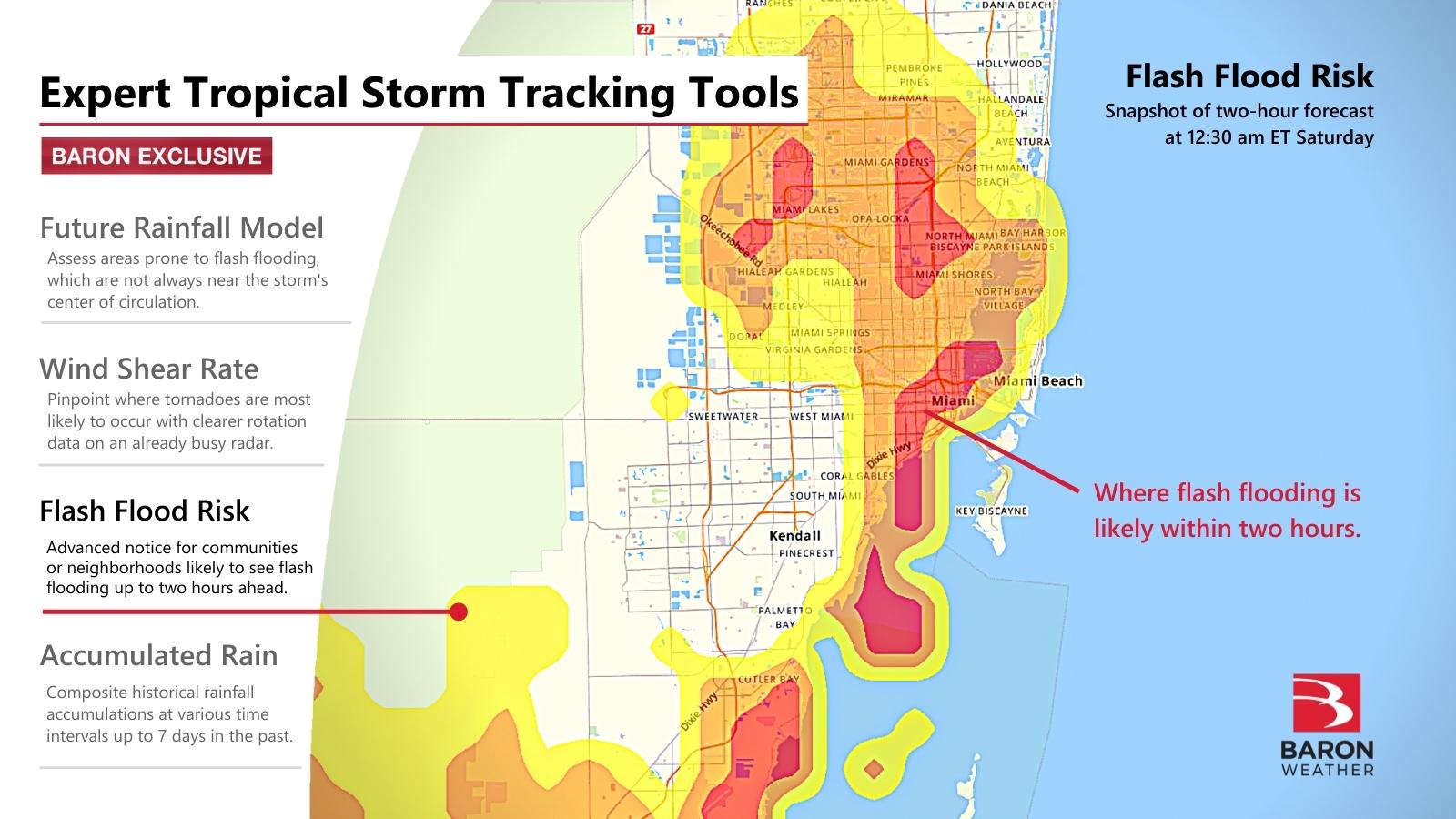
The guidance shows the threat of flash flooding over the next two hours with a superficial three-tiered risk level: Elevated, high, or very high. The model uses a high-resolution 23-year-long historical dataset of soil-moisture evolution and runoff, then matches it with recent rainfall rates and short-term modeling to pinpoint where an extreme event is likely. You can read more on this product from our case study on the flash flood event earlier this spring in Birmingham, AL.
Monitor Rainfall Amounts in Real-time
The rainfall can add up quickly during a tropical event. And there can be significant outcomes if it all comes down over a short time versus being more spread across several hours. Datasets on historical rainfall accumulations at multiple iterations can clear where rainfall rates are problematic versus just a nuisance.
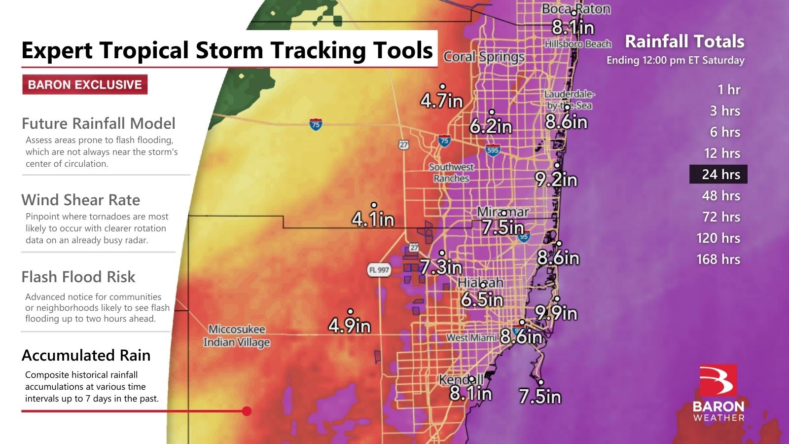
Storm total rainfall accumulations from the tropical system exceeded 12 inches in Southwest Florida. Still, the most problematic flooding occurred in the Miami metro area, where more than 8 inches fell in 24 hours.
The data products shared in this story are available to developers in the Baron API or for use by emergency response personnel in the Baron Threat Net web application. Baron experts will also stand by for decision support all through hurricane season.
