Most hurricanes tell you they're coming, sometimes a week in advance. That extended lead time can help you prepare, but also leaves room for doubt, confusion, or apathy about a forecast.
This guide can help you overcome the "information overload" problem often associated with model hype, spaghetti plots, and the infamous cone of uncertainty.
First, you need a good filter (a.k.a. this hurricane guide!). Then, learn how credible data applies to your situation. And most importantly, know when to act on it.
2026 Updates
The National Hurricane Center (NHC) tweaks its forecasts each year before hurricane season, primarily to account for improvements in forecasting and changes in media coverage.
- Inland watches and warnings added to the cone graphic: The operational forecast cone now includes inland tropical storm and hurricane watches/warnings for the U.S. and territories, improving inland wind-risk messaging.
- New storm surge products for Hawaii: Storm Surge Watches/Warnings, a Peak Storm Surge Graphic, and a Potential Storm Surge Flooding Map will begin for the main Hawaiian Islands in 2026.
- Mobile-friendly NHC website: A redesigned, more accessible front page optimized for mobile, tablet, and desktop devices will launch for the 2026 season.
- Graphical Tropical Weather Outlook update: Systems with near-zero development chances will be shown with a gray “X,” distinguishing them from low-development systems shown in yellow.
- Smaller forecast error cones: The average track forecast cone shrinks again in 2026 (about 4–8% in the Atlantic and 3–8% in the eastern Pacific) due to improved forecast accuracy.
- Experimental cone graphic: NHC will test a new cone using ellipses and along- and cross-track errors, designed to capture the storm center about 90% of the time.
- Experimental Graphical Marine Wind Warnings: New GIS-based marine wind warning graphics will provide clearer wind-threshold hazards for mariners out to 48 hours.
More information on this year's changes from the NHC can be found in this press release.
Disclaimer: This guide was constructed based on the average forward motion of a hurricane, which is 12 mph. If the storm is moving (or forecast to move) more than 20 mph, you may want to consider shifting your response daily.
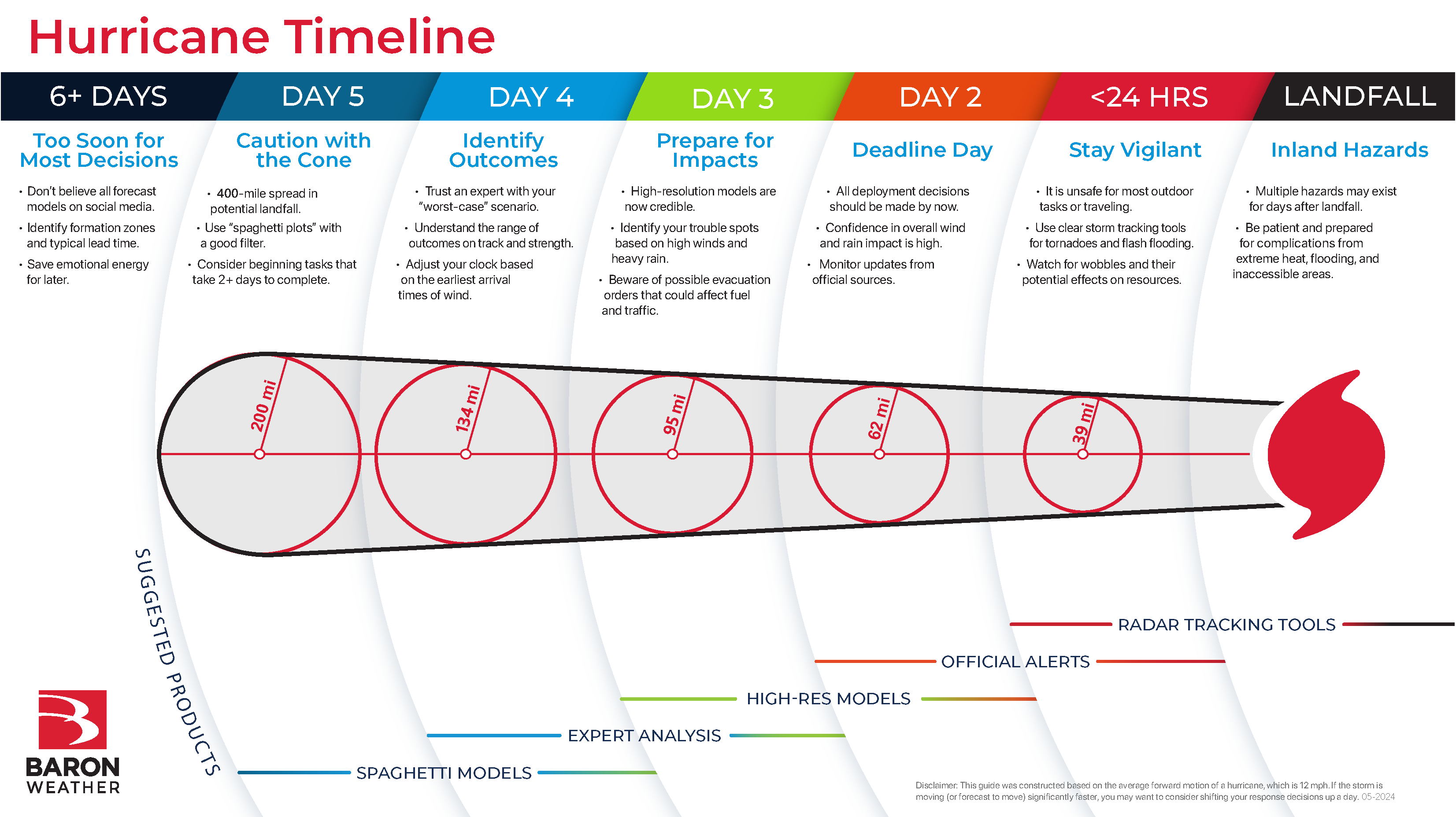
6+ Days: Too Soon for Most Decisions
The right decision at the wrong time could be costly.
Making a significant decision six or more days from when a hurricane might come ashore is usually not justified.
Paying attention to what's brewing in the tropics isn't necessarily a bad idea. Long-range forecast models have certainly come a long way. But there's a reason the National Hurricane Center (NHC) doesn't issue a forecast for a tropical cyclone more than five days out. The science beyond that time frame is just not credible.
Team Rubicon is an organization that relies heavily on donations and volunteers to help people prepare, respond, and recover from disasters. They are acutely aware of how important timely and credible weather data is to their operation.
"It would be haphazard to start moving resources or making solidified plans, you know 6 or 7 days out," says William Porter, Deputy Director of Operations Support.
"Trying to play hopscotch with models is costly, and we want to get our people as close to the impacts as possible without putting them in danger," Porter adds.
It's easy to forget how large the Atlantic Ocean is and how slowly a hurricane moves (about 12 mph). The map below represents typical lead times to the first impacts of storms aimed at the continental United States. This can be used as a good first step to filtering out unnecessary hype or fear.
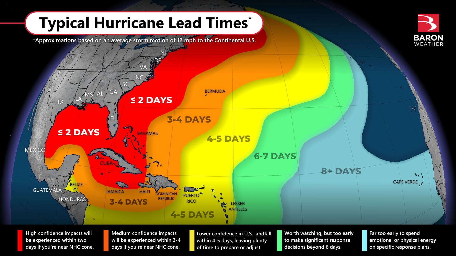
A long-track hurricane from the central Atlantic usually presents the lowest confidence forecast within five days (yellow areas on the map above). This is a product of distance, atmospheric conditions, and potential obstacles through the northern Caribbean or the Bahamas. If a storm forms in the Caribbean or western Atlantic, the typical lead time is usually four or five days, but even these can miss the U.S. entirely.
You can save some emotional energy - which will certainly come in handy later - by not stressing over the forecast model snapshots beyond five days. However, if your hurricane plan necessitates the movement of large quantities of resources, some regional planning may make sense at this stage.
What if a storm forms close to the coastline?
Not all storms will have a five-day lead time. If a tropical storm or hurricane has formed close to your coastline (e.g., the red areas on the map above), you may need to skip ahead a day or two and move much faster with your decision-making process.
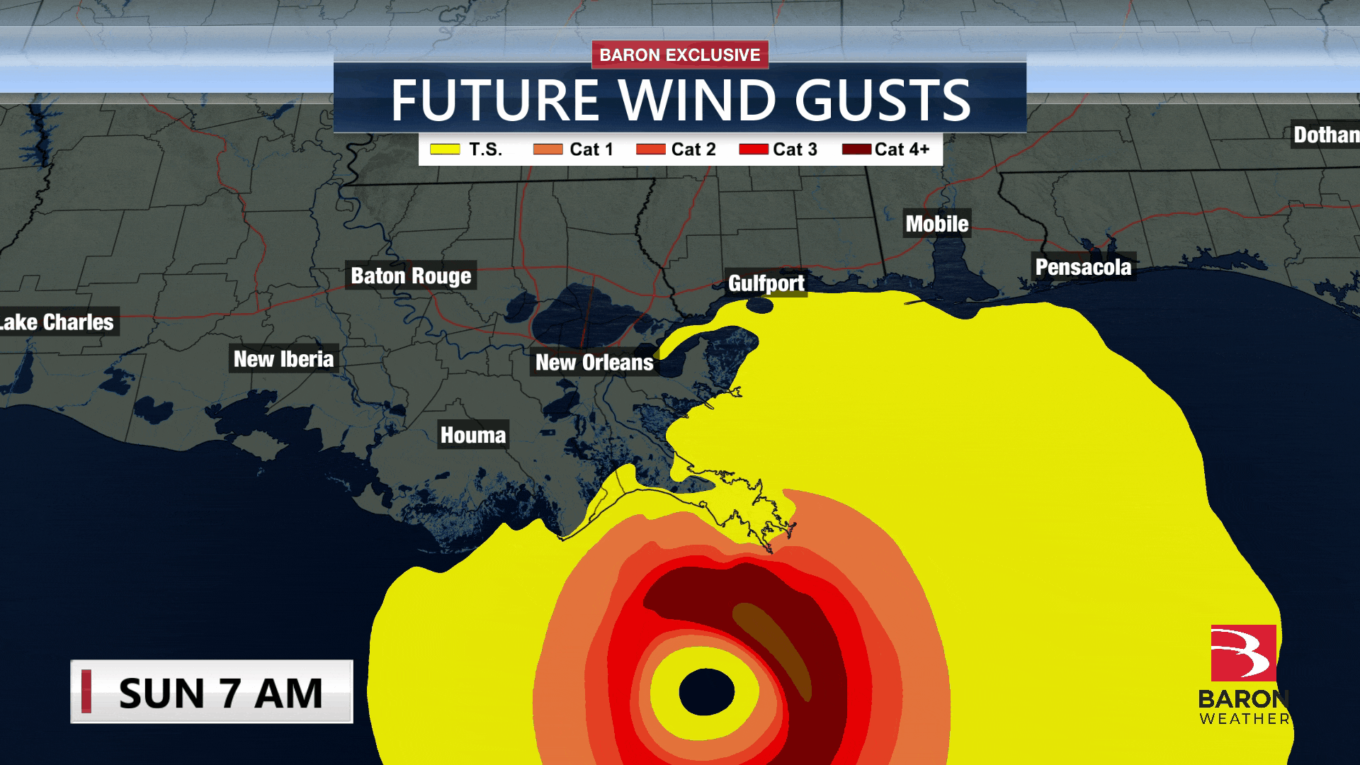
Five Days: Caution with the Cone
We have a cone! If you're in the path of the cone or close to it, there is still plenty of time. Use caution at this time when pulling the trigger on something that could turn into a costly mistake, especially if it can wait another day. The margin of error of a forecast cone from the National Hurricane Center 120 hours out is 205 miles in either direction. And this still only happens 2/3 of the time. That's a 410-mile spread in potential landfall.
"We're going to start moving things around five days out, calling in folks to our operations center, for example. But we wouldn't start prepositioning people that early," Porter said.
Spaghetti plots are somewhat helpful at this time frame, as they can communicate confidence in the forecast. However, make sure you follow these best practices…
- Filter out the models that don't perform well.
- Look for groupings of the lines into two or more definable paths.
- Overlay the NHC cone of uncertainty to determine forecast confidence.
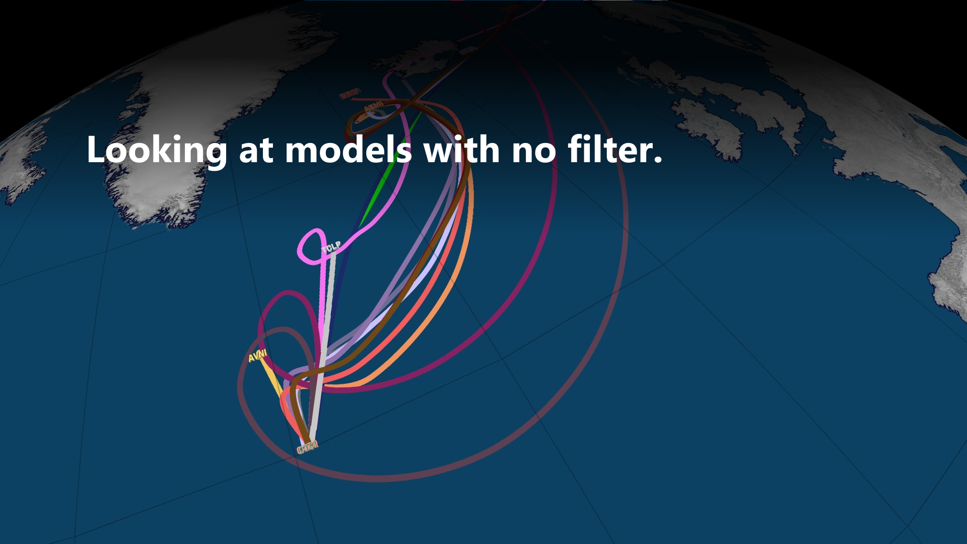
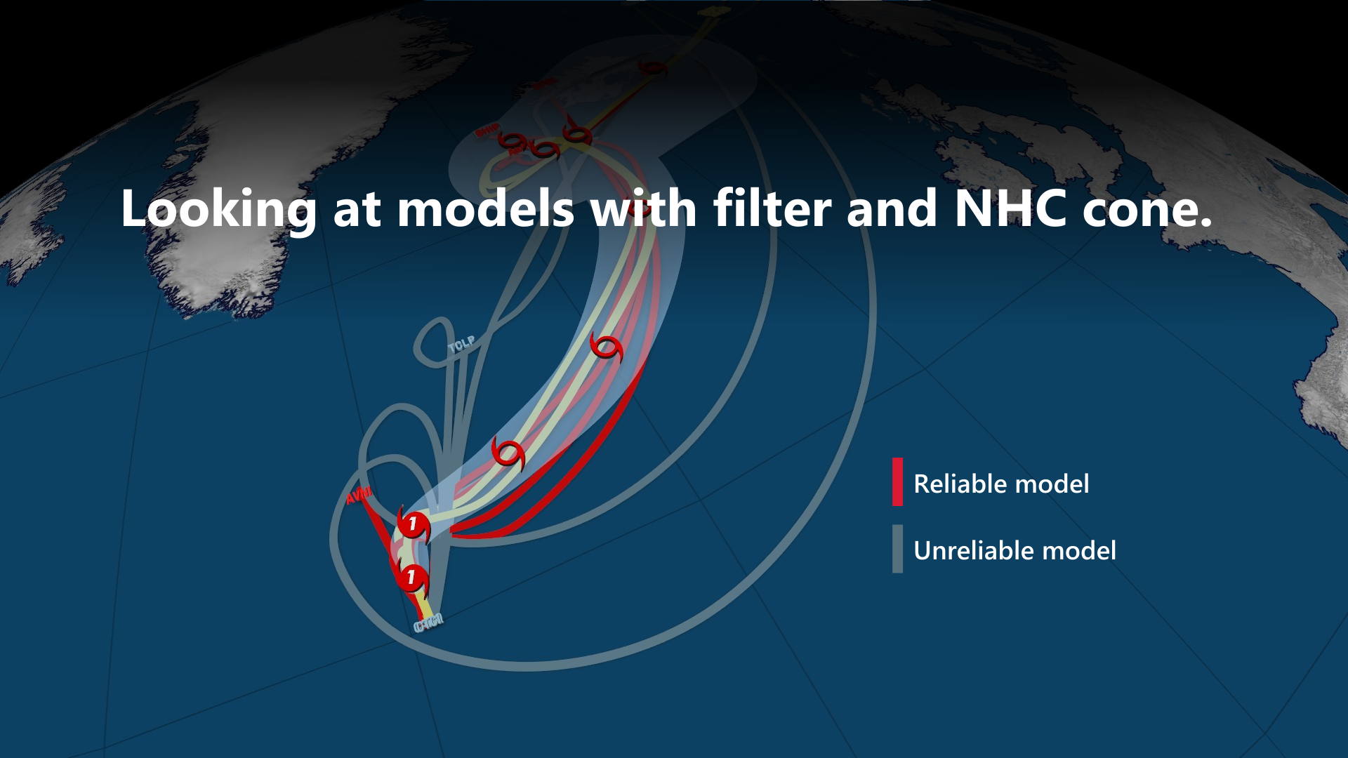
In the example above, Baron Lynx software visualized both the NHC cone and the models on one map (right). This can also be displayed in the Baron Threat Net web application.
Important reminder
The spaghetti plots and NHC cone only represent the storm's center. Impacts can, and often do, occur hundreds of miles from landfall and consequently far outside the forecast cone as it narrows.
Four Days: Identify Outcomes
Every waking moment becomes increasingly critical when you're four days from landfall. This is where an expert meteorologist can help you calculate what a worst-case scenario may look like.
You want to ensure you factor in the appropriate level of strength uncertainty, not just the track. The average margin of error on storm intensity at 96 hours is around 15 mph of maximum winds. Emergency managers often encourage preparations for one category higher than explicitly forecasted.
Forecast data is becoming much more reliable at this point, usually identifying a smaller range of potential outcomes. However, there could also be two distinct scenarios to consider. For example, the storm may (or may not) cross a landmass and weaken, or the storm may (or may not) move through an area of favorable conditions for intensification.
Adjust your countdown clock
Factor in the earliest arrival times of tropical storm-force winds to your worst-case scenario. Rather than focusing on one forecast model at this stage, we recommend using the NHC's earliest arrival time map to give yourself a deadline for ALL preparations. You can then adjust your countdown clock (and this guide) appropriately to ensure you're on track based on the time of day.
Three Days: Prepare for Impacts
Now, it's time to pay close attention to higher-resolution forecast models. They often exhibit the skills necessary to make difficult decisions on strategically positioning resources out of harm's way, both during and after landfall.
William says Team Rubicon usually feels "comfortable" on day three, when he puts his plan into action. "We know at this point we can get people as close as possible without putting them in danger, allowing them to respond more rapidly," he says.
The most important impacts to assess at this stage are the magnitude and timing of heavy rainfall and high winds.
Flash flooding and widespread infrastructure damage can disrupt a supply chain response, sometimes hundreds of miles from where the eye comes ashore. Insights on where your trouble spots may be are credible for the day of landfall, with further refinement on inland areas in subsequent days to come.
Be aware of evacuation orders
Be aware that evacuation orders issued on this day (or the next) may further complicate your ability to move resources and respond appropriately. Every state has unique evacuation zones and routes, and it might be a good idea to monitor the state emergency management websites where your response may be compromised.
Day Two: Deadline Day
Nearly all final resource and response preparation decisions should be made today. Tropical storm conditions often arrive 12 to 24 hours ahead of landfall, which could be before sunrise tomorrow. Confidence in the overall magnitude of impact is also significantly higher, increasing your ability to complete appropriate action plans.
Storm surge depth and the precise path of the strongest winds are the two hazards most prone to shifting within 48 hours of landfall. Constantly monitoring the high-resolution model simulations mentioned on day three can help you identify subtle trends in the storm track. Updates are typically available four times per day, usually around 4 am and every six hours after that.
Another tool that Team Rubicon relies heavily on is an alerting application that can be set up for multiple locations.
William says it's such a "relief" to his team to know they can get timely alerts for things like tornadoes and high wind gusts, no matter where his team is.
"Our people on the ground have to be aware of their surroundings at all times, making sure their supplies stay secure and people they need to reach are accessible."
Why your plan should be set by now
Official tropical storm, hurricane, and storm surge watches and warnings are usually issued 36 to 48 hours before a storm. These can trigger specific actions or directives from emergency managers and the media, potentially inducing fear or shadow evacuations. Be sensitive to how changes in traffic patterns and overall stress might affect your employees and their families. Your business response plan should be set by now, and only minor tweaks should be necessary.
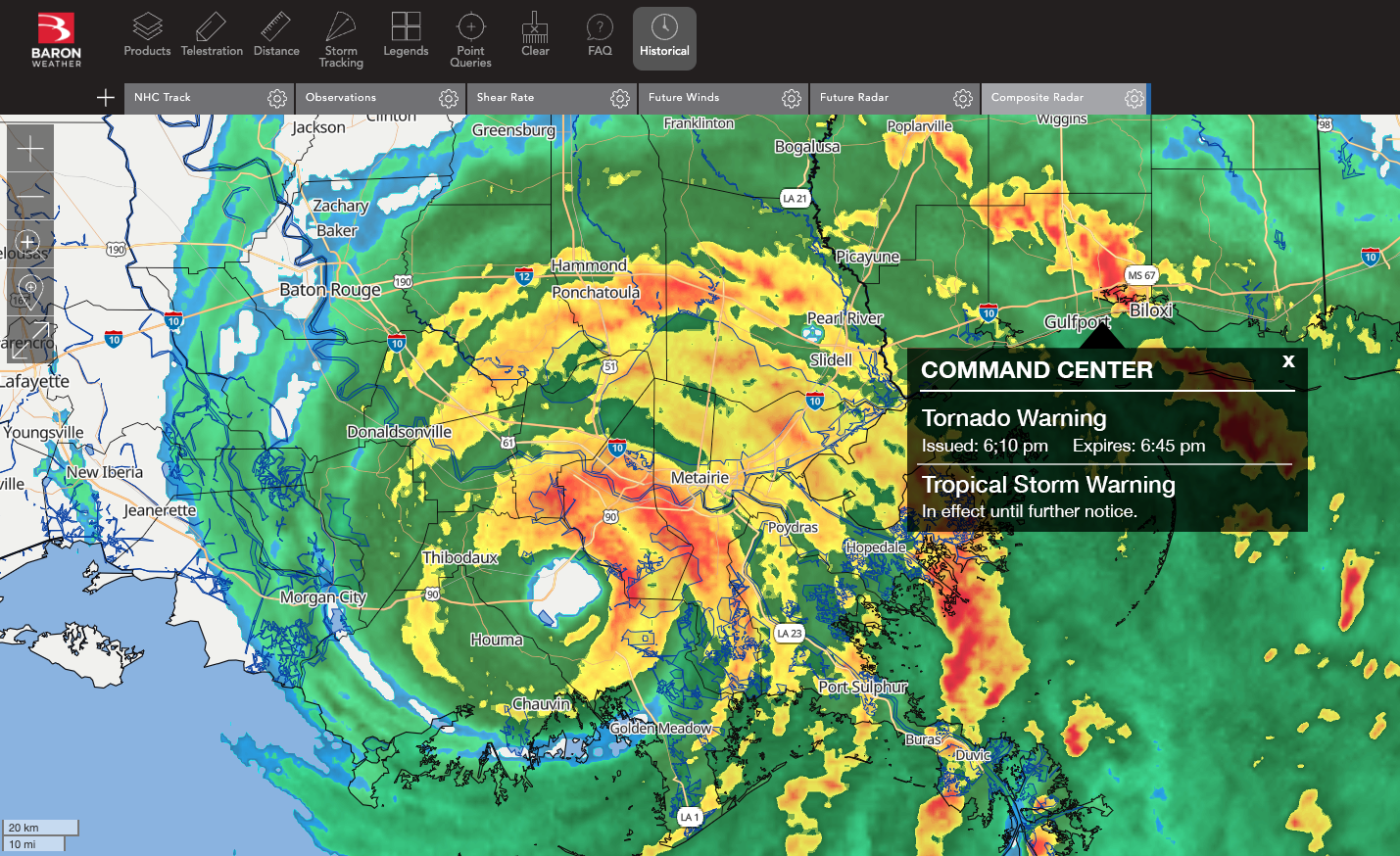
24 Hours: Stay Vigilant
It is now unsafe for most outdoor tasks or traveling, but there are things to watch for as every outer band comes ashore. Tornadoes can spin up quickly and suddenly put assets at a greater risk.
A standard radar map is full of color when a hurricane is approaching. This can make it difficult to understand the potential threats from a storm's outer bands. For example, data tools that highlight wind velocities can help you identify tornadoes that may suddenly spin up.
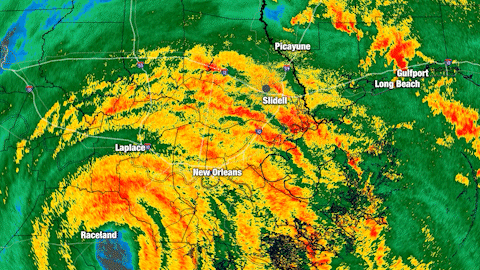
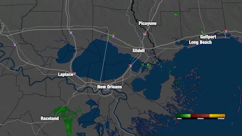
The animation above visualizes standard radar data (left) compared to Baron's derived Shear Rate (right). This example was rendered using the Baron Lynx broadcast software, but the data is also available in the Baron API or on Baron Threat Net.
Hurricanes often wobble, sometimes shifting the path of the strongest winds or highest storm surge by dozens of miles. We recommend having an "always-on" tracking tool that is mobile and bandwidth-friendly so you can watch observations and updates constantly.
What you can do if there's a wobble
Even though it may be unsafe to move resources or change your plan as the eye is coming ashore, you can recognize potential liabilities from a storm's wobble and be ready to adjust accordingly as soon as it is safe to do.
Landfall: Watch for Inland Hazards
Multiple hazards may exist for several hours or even days after a hurricane moves inland. Bands of heavy rain can delay the recession of floodwaters, tornadoes can still pop up, and it can become dangerously hot and humid in the storm's wake. Your hurricane plan should account for these complications, and the task of monitoring the weather should continue.
No two hurricanes are alike. While there are similarities in how you might prepare for one, every storm's path and motion are unique and require strategic thought and flexibility. The timing of your implementation can be just as important as the planning itself.
We hope this guide can improve the efficacy of your response by giving you confidence in when to make those difficult decisions. We've given you several brief examples of how Baron technology could benefit your organization. Our weather experts are ready to demo how our smarter weather data can help you make better hurricane decisions.![]()
