The globe is about to catch a huge fever.
El Niño has arrived, the National Oceanic and Atmospheric Administration (NOAA) announced Thursday.
The phenomenon develops every three to seven years, and its impacts have been studied for decades. But this one could be strong, likely resulting in abnormal global weather events through 2024. Some of them could be extreme.
Smarter weather data can help your team avoid any El Niño weather surprises by empowering proactive (not reactive) decision-making.
You can skip ahead here...
What is El Niño?
El Niño occurs when the trade winds, which blow from east to west across the Pacific Ocean, weaken or reverse. This weakening allows warm water to move eastward toward the coast of South America. This causes changes in atmospheric circulations, affecting weather patterns worldwide.
An El Niño is declared when a warm spell is observed across the equatorial waters of the Pacific Ocean for three successive months. A La Niña is the opposite phase when cooler-than-normal water temperatures persist in the same region.
This back-and-forth phenomenon is one of the greatest influencers of global weather patterns known to man, and it varies from decade to decade in how frequently it cycles.
Global Effects of El Niño
Oceans cover 70% of the Earth's surface, making them the largest influencer on our globe's weather and climate. Heat, moisture, and carbon are constantly exchanged between the water and the atmosphere. This is why the occurrence of an El Niño has such a far-reaching effect on weather patterns in nearly every continent.
El Nino "increases the odds" of significant impacts from heavy rainfall and drought in certain locations around the world, NOAA climate scientists said in the announcement. Depending on its strength, a range of impacts could occur. And climate change can "exacerbate or mitigate" impacts such as global temperatures that are already above average.
One of the biggest near-term influences of El Niño will be on the upcoming hurricane season. Research has shown it has strong connections to the quantity and magnitude of tropical cyclones in the Atlantic.
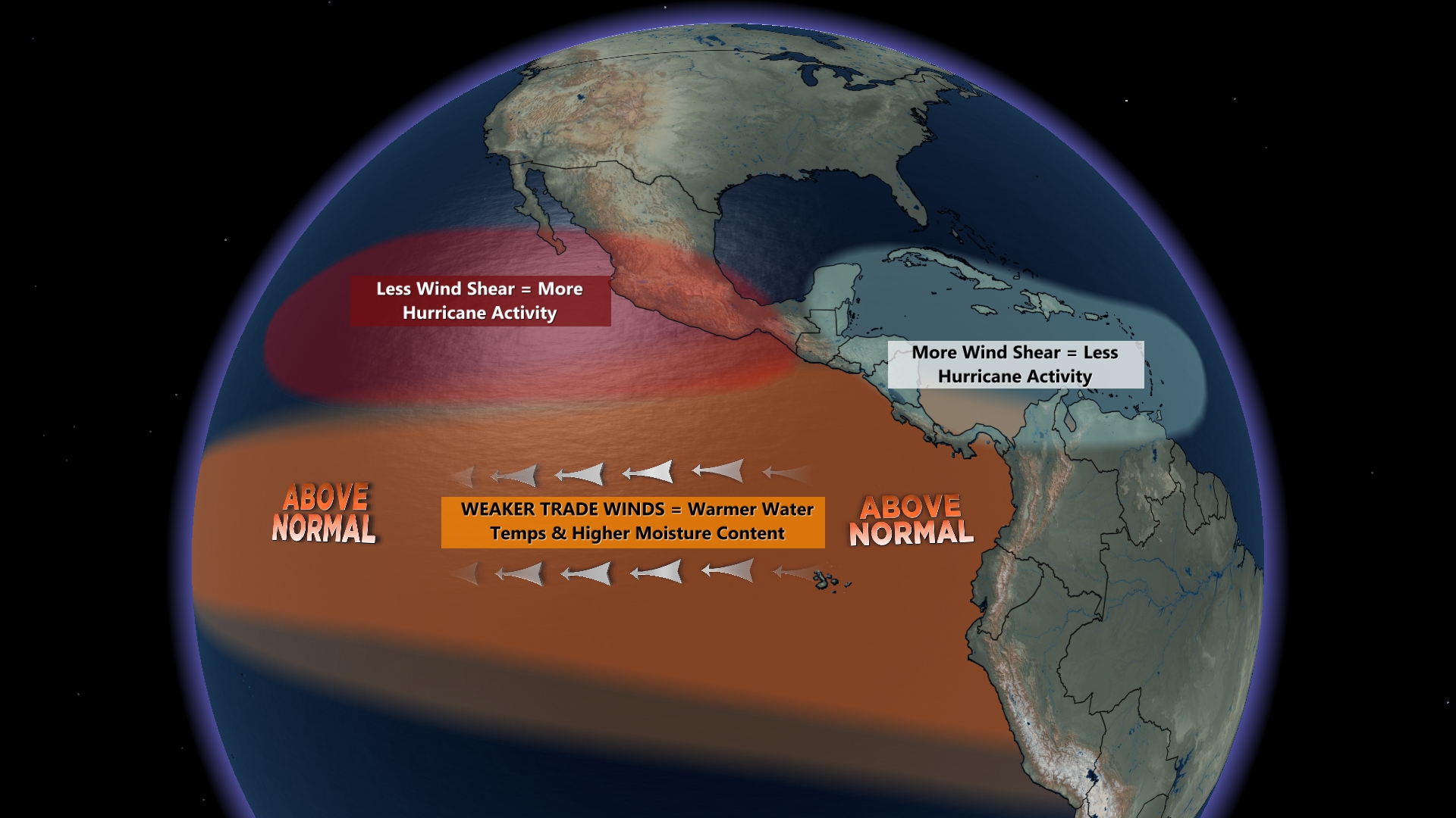
The warmer Pacific waters cause more upward motion and a stronger, more amplified jet stream (steering current) across Mexico and into the Caribbean Sea. Stronger upper-level winds (or wind shear) can rip a developing hurricane apart or even prevent it from forming. However, it remains to be seen how strong El Niño will be by early fall and how much influence it will have on the Atlantic hurricane season.
Other northern hemispheric effects of an El Niño are most evident in the winter season. For example, a stronger subtropical jet stream supplies more moisture to storm systems moving across the southern tier of the United States, while drier and warmer weather is typically found across the Pacific Northwest, Northern Plains, and much of southern and western Canada.
El Niño driven climate anomalies also occur in other parts of the world, especially near the equator and across the southern hemisphere. Drought conditions usually develop across India, Indonesia, and the coastlines of South America. And pockets of extreme rainfall and flooding are typically observed in eastern China, portions of eastern Africa, and Argentina.
Tools to Help You Prepare for El Niño
A series of extreme weather events will likely occur over the next couple of years that can be linked to the developing El Niño. This could worsen the upcoming fire season across the Pacific Northwest, enhance the rainy season in California, and produce more frequent tornadoes across Florida this winter.
Now is the time to review your weather detection and forecast tools so that you have plenty of time to implement them and prepare for El Niño's impacts.
The most challenging task during an El Niño is preparing for extreme events weeks or months in advance. Baron has partnered with Weather 20/20 to offer businesses a new way of detecting and tracking the potential for a major storm or recurring pattern.
Baron also offers a wide selection of wildfire and drought tracking data, including a 7-day hotspot analysis and precipitation anomalies over the past 365 days.
Flash flooding is a relatively smaller but dangerous event that is often a byproduct of an El Niño induced relentless rainy pattern. Baron has built a specialized model for detecting a flash flood threat up to two hours before the waters rise.
Baron has been building advanced storm-tracking technology for more than 30 years. The Baron Shear Rate product (often called "Spin Detector") is one of the more recent advancements, helping you accurately and easily detect a developing tornado inside a thunderstorm on radar. This can supplement the freely available data you might already use in detecting strong or severe thunderstorms.
Understanding your potential risks is the first step to preparing for El Niño's impacts. The exclusive technology mentioned in this story is available through the Baron API, the Esri Marketplace, and public safety or media professionals through proprietary software. We have experts standing by to help you discuss solutions specific to your needs.
