Tornadoes, flash flooding, ice, snow, and extreme temperature swings are more likely to occur this winter across the Southern Plains and Southeast, largely due to an established El Niño.
Now is a good time to assess your organization's continuity plans to ensure you have the proper tools in place to prepare for any extreme weather events that may occur in an El Niño winter.
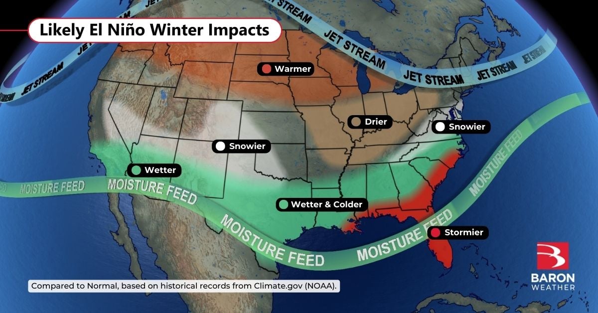
A Strong El Niño is Likely
The El Niño-Southern Oscillation Outlook (ENSO) was updated by the Climate Prediction Center Thursday morning, stating with certainty that an El Niño will continue through the spring of 2024. Forecasters say there is now a 75-85% chance of it peaking as a "strong" event this winter and even a "3 in 10 chance" that it will become a historic event.
Researchers have discovered that the strength of an El Niño doesn't necessarily mean its impacts will be stronger, but rather, the chances of those impacts occurring are higher. El Niño is identified as a period of above-normal water temperatures in the Pacific Ocean near the equator. The phenomenon disrupts the normal circulation pattern over the oceans and atmosphere, resulting in global weather and climate abnormalities.
The South: Frequent Precipitation Events
The most notable influence of an El Niño in the winter months is the placement and enhancement of the subtropical jet stream. This is the river of air that steers moisture across North America from the Pacific Ocean. It will likely be much stronger and more persistent this winter, resulting in numerous precipitation events from Southern California through Texas into the Southeast.
The persistence of this moisture stream will interact with fronts and storm systems to increase the potential for flooding, especially where rounds of heavy rain repeat themselves over the same areas. The promise of rain will be welcome news to many from Arizona to Louisiana, where moderate to extreme drought is ongoing.
Flash flooding is one of the top weather-related killers in the country. Baron developed a derived real-time risk dataset to provide accurate and advanced notice down to a street level where a life-threatening event is likely to occur. We've shared examples of the data during extreme flooding events below.
The Southeast: Elevated Tornado Risk
The amplification of the subtropical jet stream will make warm and humid air more readily available across Florida and adjacent states of the Southeast. This will likely fuel stronger thunderstorm development ahead of approaching fronts or low-pressure systems. And when rotation is present, the stronger jet stream and available energy will enhance the tornado risk.
The correlation between El Niño and an increase in tornadoes in Florida has been well studied. There is also evidence that violent tornadoes are more likely to occur during El Niño years in Florida, especially during the latter half of the season and across central and southern regions of the Sunshine State.
Evidence that El Niño may already be enhancing thunderstorms across Florida occurred in the early hours Thursday morning.
@BaronWeather Klystron9 performed perfectly last night…giving us more than a half hour lead time alerting people of the approaching tornadoes. Very distinct High-Res hook signatures that we tracked at neighborhood accuracy pic.twitter.com/aTtsfmjt4x
— Brian McClure (@mcclureWX) October 12, 2023
Many of the winter tornadoes that occur in the Southeast happen late at night, making those in their path even more susceptible to life-altering impacts. Baron Weather was founded on groundbreaking storm-tracking technology, and our development team continues to improve automatic alerting and visualization tools to detect and track tornadoes. You can read more about this technology in the stories shared below.
Southern Plains to Mid-Atlantic: Higher Snow Potential
Snowfall tends to be above average across the Southern Plains and Mid-Atlantic states during El Niño winters. This is likely a byproduct of the more active subtropical jet stream steering moisture into cold air masses sliding down from the north.
The correlation of heavier snow events to an ENSO signal is not as strong across other portions of the South, but many cities do often report near or slightly above average snowfall amounts during an El Niño from Texas to the Carolinas.
Baron Weather offers a full suite of winter weather tracking data, including exclusive road condition forecasts and future ice and snow models. We've shared some tips on how to prepare for winter stories below.
Northwest to Midwest: Drier and Warmer than Normal
Not all impacts from El Niño are perceived as dangerous or bad. Many who typically endure long, cold, snowy winters may get a break this year.
The polar jet stream is responsible for directing colder air masses into the United States from time to time. During an El Niño, it's often displaced farther north, resulting in less frequent and less extreme cold snaps from the Pacific Northwest into the Northern Plains.
Drier winters are also notable during El Niño years across portions of the Ohio Valley and Midwest, likely due to fewer interactions between the subtropical and polar jet streams.
How Smarter Data Can Help
No two winters are alike. While there are similarities in how you might prepare for them, every weather pattern and storm system is unique and requires strategic thought and flexibility. The timing of your decisions can also be just as important as the planning itself.
Smarter data from Baron Weather can provide clarity and early notice on potential disruptive winter weather events. Let us know if you want to talk to an expert and discuss how our superior weather data can help you make better winter weather decisions.
