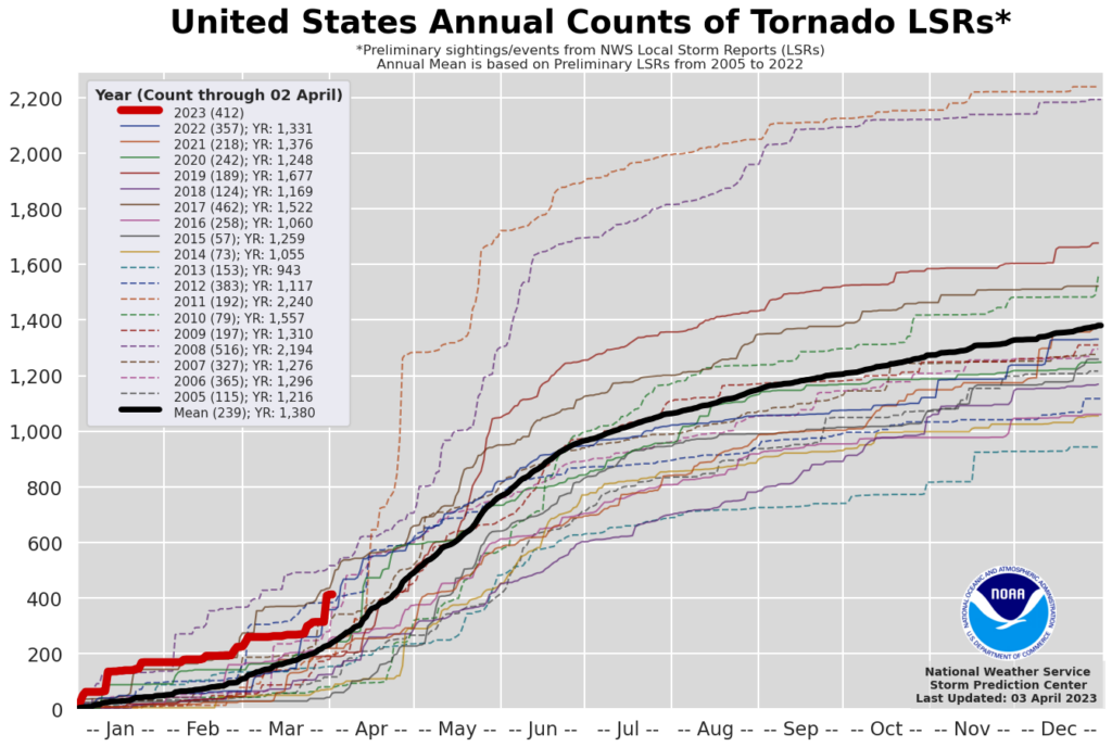
2023 is on pace to have one of the most active tornado seasons since 1950, even before the historically most active tornado month of the year arrives.
The fast start to tornado season is not necessarily a precursor of the entire year, and it could be related to lingering influences from a recent La Niña.
Tornadoes are inherently difficult to predict and prepare for. They develop quickly and often only affect a small percentage of the population. Far fewer people are directly affected by a tornado than receive the warning.
This is where smarter data can help. Having the right tools in place to accurately pinpoint a tornado's location and time of arrival is key to making life-changing decisions when every second matters.
2023 Tornado Season in Context
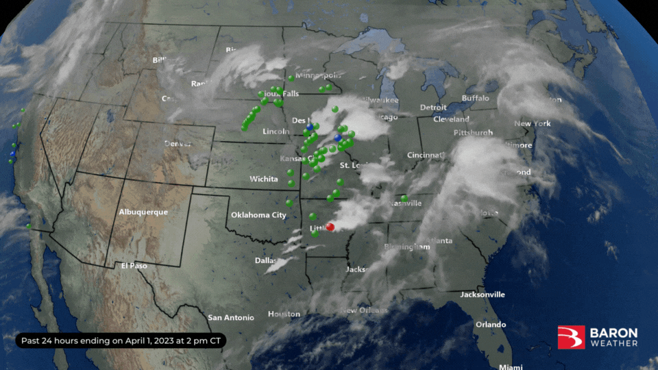
Over 100 reports of tornadoes came in Friday, bringing the three-month total to 420, according to preliminary data from the Storm Prediction Center (SPC). As each report is verified, these numbers will be adjusted, but it is likely to at least rank in the top 3 since 1950.
The 3-month trend is decidedly near the top since 2005 and is second only to 2008 and 2017.
The year has also been a deadly one, with 63 tornado-related fatalities reported as of April 1. The outbreak over the weekend (Mar 31-Apr 2) killed 32, according to multiple reports. This closely followed the March 24 outbreak that claimed 22 lives, nearly all of whom were in Mississippi.
Lingering Influences from La Niña
The strongest global indicator of abnormal weather activity is the El Niño-Southern Oscillation (ENSO), a recurring climate pattern involving changes in water temperatures across the central and eastern Pacific Ocean. A relationship has been found between the ENSO signal and winter and spring severe weather seasons.
A La Niña has been present for nearly two years, and this phenomenon correlates to higher-than-normal tornado activity in the South. The cooling of surface ocean water along the west coast of South America enhances factors such as instability and wind shear from Texas to Tennessee in the winter and spring months.
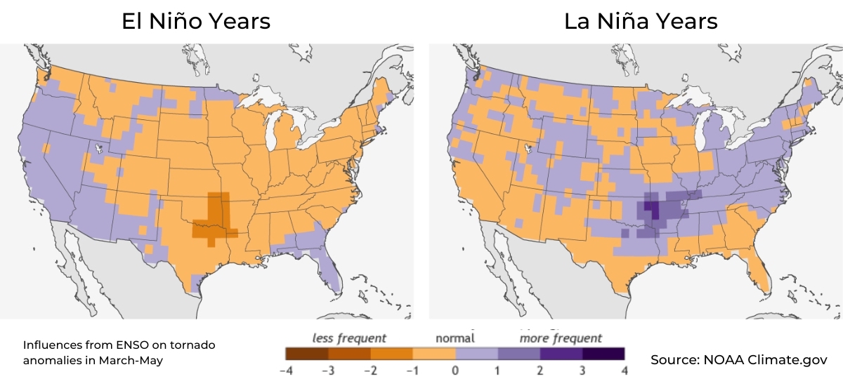
However, the research also clarifies that a "tremendous variability" in severe thunderstorm activity can sometimes be unexplained by fluctuations in the ENSO index. Therefore, blaming this year's high activity solely on La Niña would exaggerate this relationship's strength.
NOAA forecasters announced on March 9 that La Niña had ended and that ENSO neutral conditions were expected through early summer. Climate forecast models indicate an El Niño, opposite of La Niña, has a greater than 50% chance of developing by fall. This will likely be too late to significantly reduce severe weather activity in the same areas vulnerable to tornadoes during severe weather season in the South.
How Smarter Data Can Help
Several months of potentially destructive tornadoes lie ahead. And in some regions of the country, such as Florida, tornadoes can strike any time of year. Understanding the risk to your life or property is the first step. Taking immediate action on intelligent, reliable data is the lifeline.
Baron Weather founded the storm-tracking technology you now see in almost every weather app. The timeline below walks you through three decades of mission-minded innovation from Baron Weather in the interest of public safety with severe thunderstorms.
30 Years of Storm-Tracking Innovation from Baron
Thirty years of innovation later, we can not only accurately display a tornadic circulation down to street level but also reliably predict where tornadic storms are likely to develop up to 60 hours in the future. The exclusive Baron Future Spin model is often used to highlight thunderstorms that are forecast to exhibit rotation versus run-of-the-mill activity that is more common.
The exclusive Baron Shear Rate product (often referred to by broadcasters as "Spin Detector") eliminates other radar imagery, the so-called "noise," to help public safety officials focus on the truly life-threatening elements of a severe thunderstorm.
Once a tornadic circulation is identified, we take the guesswork out of where it's headed and when it will arrive. A Baron Storm Cell Identification and Tracking marker (SCIT) uses storm speed and motion to display arrival times at points of interest along its path. This technology is essentially the full stop (or final answer) to whether you or your assets are in immediate danger from a tornado.
The Baron Future Spin model, Shear Rate, and storm tracking (SCIT) technology are available to broadcasters, public safety professionals, and app developers. Baron also has developed exclusive technology for identifying hail, high winds, and flash flooding to empower your severe weather tracking. We have  ready to help you discuss solutions specific to your needs.
