A tropical storm hitting California probably wasn't on your 2023 bingo card, but there were key indicators well in advance.
Preparing for an extreme rainfall event isn't easy, especially when it's unprecedented and doesn't feel like it could really happen. But smarter data can help. And knowing how and when to use it can dramatically improve your critical decision-making.
The Signs Were There a Week Out
Long-range forecast models began hinting on Aug. 14 that tropical activity might develop and potentially impact the Baja of California. Forecasters at the National Hurricane Center started monitoring a disturbance for potential development a few hundred miles west of Central America. This is also when the Baron Extreme Weather Index first suggested a high-impact event might affect Southern California.
Two days later, Tropical Storm Hilary formed over the Eastern Pacific, about 470 miles south-southeast of Manzanillo, Mexico. By midday on Aug. 16 -- four days before the storm would come ashore -- the extreme rainfall index from Baron had increased from "excessive" to "extreme" from Reno, NV. to Palm Springs, CA.
The timeline below includes snapshots of the new Baron Extreme Weather Index at key moments during Hurricane Hilary's development.
It's rare to get substantial rainfall in this region over the summer, outside of a few monsoon showers. But the Extreme Weather Index was built for these situations. Any indication of heavy rain in the Desert Southwest at this time of year would be noteworthy. And multiple runs of Baron's Extreme Weather Index consistently indicated an "extreme" event was likely.
Details on the Extreme Rainfall Two Days Prior
Confidence continued to increase that abnormal amounts of rain would fall in a short amount of time near and east of where Hilary's center of circulation would track. The storm intensified to a major Category 4 hurricane by Thursday night, Aug. 17. However, Hilary was expected to weaken significantly before landfall. Nonetheless, upper-level winds were projected to steer all of its tropical moisture into the Golden State, leading to historic rainfall.
Details matter during events such as Hilary, especially where the added lift from mountainous terrain can enhance rainfall rates. This is where the exclusive Baron model excels: Helping businesses and emergency managers plan for weather extremes on a hyperlocal level.
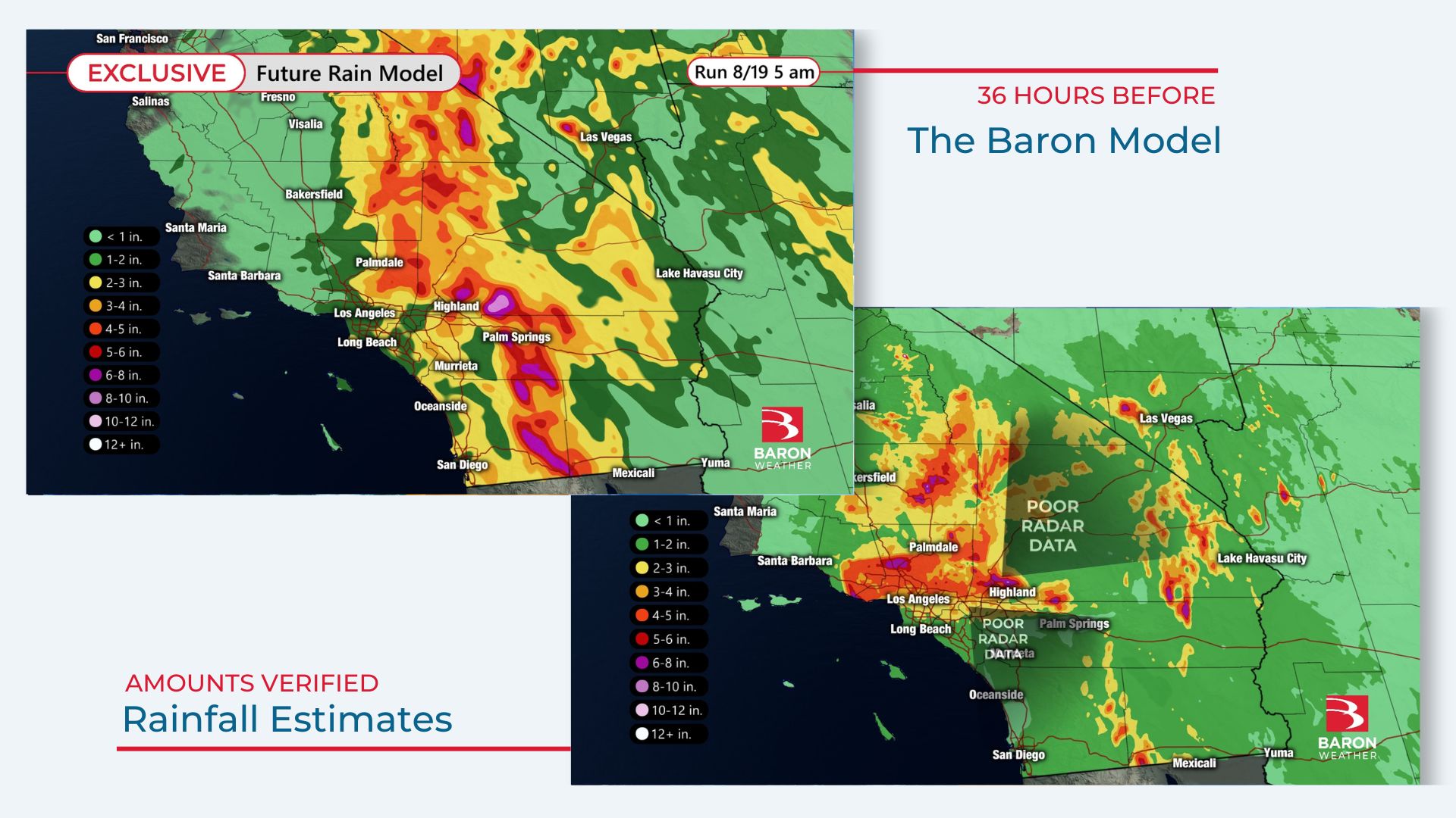
The Baron Future Rain model -- both in timing and amounts -- highlighted how extreme and persistent the rain would be over the higher terrain of the Traverse Mountains. Over eight inches of rain accumulation was projected on the peaks of the San Bernardino Mountains north of Riverside and west of Palm Springs.
Three-day radar-derived rainfall estimates -- in particular, where there was quality data -- were in the 8 to 10-inch range at the highest elevations north of Highland, CA. Observed amounts were also verified in these locations, with the highest report occurring at the top of Mount San Jacinto, where 11.74 inches of rain fell.
Up to Two-Hour Notice Given on Flash Flooding
Minutes matter when a flash flood event is unfolding. Heavy rain by itself doesn't always cause a flash flood. Topography, land surface types, and prior rainfall amounts all play a significant role in how quickly a road or stream will flood. Knowing where and when you might need to position your response team isn't easy when the weather situation is so complex.
The Baron Flash Flood Risk is a perfect guide for these situations. The exclusive model considers land surface conditions, prior rainfall, and expected rainfall to pinpoint where flash flooding is most likely to occur or emanate from. And it can give users up to two hours advance notice.
The map comparison below highlights all of the areas that were highlighted by Baron's Flash Flood Index on Sunday, Aug. 20, while the heavy rain from Hilary was moving through Southern California.
Note: Some reports fall outside Baron's Flash Flood Risk because creeks and rivers rose out of their banks well downstream from the highest rain rates.
Maximum tropical storm-related rainfall records were set in four states from Hilary: Nevada, Oregon, Idaho, and Montana. An all-time record for rainfall in a 24-hour period was set in Nevada near Reno, where 9.2 inches fell.
The National Hurricane Center issued its first-ever Tropical Storm Warning for Los Angeles and San Diego as Hilary approached, and nearly every reporting station in Southern California shattered daily rainfall records for Aug. 20.
The exclusive technology mentioned in this story is available through the Baron API, the Esri Marketplace, and public safety or media professionals through proprietary software. We have experts standing by to help you discuss solutions specific to your needs.
