NOAA scientists have increased their prediction for this year's Atlantic hurricane season, expressing confidence that record-warm ocean temperatures are "likely to counterbalance" the typical limiting conditions from the ongoing El Niño event.
The update from NOAA's Climate Prediction Center, which was released Thursday, is consistent with several other forecast updates that now nearly all point to an above-average hurricane season.
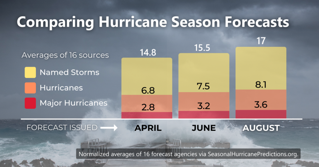
The Increase by the Numbers
Colorado State University scientists have been tracking credible hurricane forecasts since 1966. Data from their website shows an average forecast increase of two named storms, one hurricane, and one major hurricane since April. NOAA's forecast increase is slightly higher than the average, which now calls for 14 to 21 named storms and 6 to 11 hurricanes, of which 2 to 5 will become major hurricanes.
The graph below represents the normalized average forecast numbers from 16 organizations and how they've changed since April.
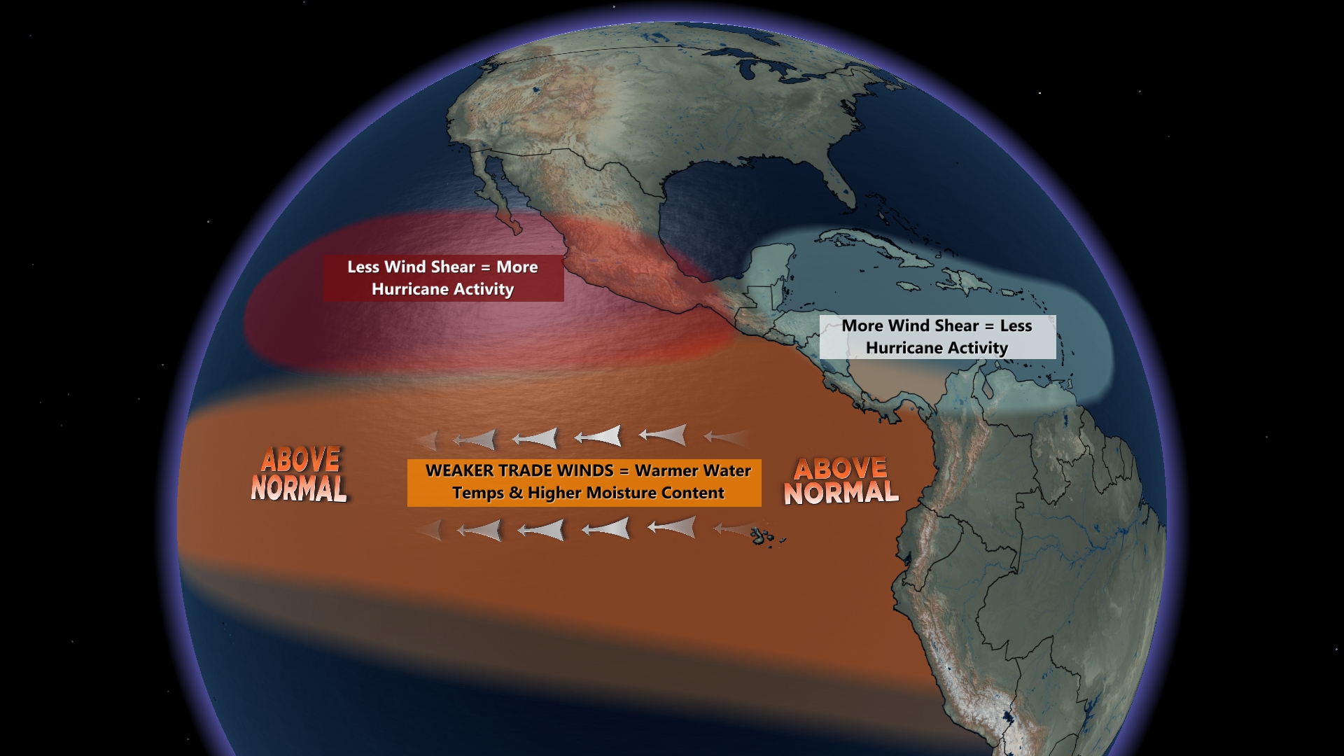
The methodology of most seasonal forecasts is largely focused on the total number of storms across the entire Atlantic basin. However, some forecasters have more recently begun to study trends in where tropical activity is more likely to track in a given year. Weather 20/20 is one such example, a company that uses a pattern recognition technique called the Lezak Recurring Cycle (LRC) to deliver forecast insights up to a year in advance. Weather 20/20's forecast identifies eastern Florida and coastal North Carolina as "hot spots" for tropical activity in September.
As of August 10, five tropical storms and one hurricane have already formed this year, including an unnamed storm in January that was later classified subtropical. The traditional peak of tropical cyclone activity in the Atlantic basin is early September, and 75% of all major hurricanes form after August 15 on average.
Why This Year's Forecast is Difficult
Competing factors have made this year's long-range seasonal hurricane forecast difficult. The primary reason for the more active forecast is the extremely warm sea surface temperatures observed across the Atlantic Basin. The warm water serves as the fuel for hurricanes to form and intensify.
The biggest roadblock to hurricanes this year is the presence of El Niño in the Pacific Ocean. An El Niño typically produces stronger winds aloft that move across Central America and disrupt storm potential in the Caribbean and western Atlantic.
The uncertainty was centered around whether El Niño would be strong enough to suppress hurricanes, despite the unusually warm water. Forecasters from the CPC also issued an updated El Niño forecast Thursday, expressing more confidence in a "strong" event, but stating that it would not reach that status until winter.
Atmospheric and oceanic conditions favorable for hurricane formation can still occur despite larger global inhibitive patterns. In fact, several strong and impactful hurricanes have historically hit the United States during El Niño years. Hurricanes Andrew (Florida, 1992) and Alicia (Texas, 1983) were deadly, multi-billion-dollar disasters that occurred during El Niño years and relatively inactive seasons.
Is Smarter Data in Your Hurricane Plan?
Hurricanes and tropical storms are individual events that can disrupt operations or destroy property with only a few days' notice. And they can strike any coastline on any given year, regardless of the seasonal forecast or overall weather pattern. It may only take one storm to put you out of business or blow your claim's budget.
Hurricanes are complex. The logistics of loss avoidance, mitigation, and response are even more complicated. You can avoid the pitfalls of a hurricane season forecast by preparing appropriately for one storm. Tracking a cone of uncertainty and waiting on a warning often doesn't cut it; smarter data specific to your needs is available.
And knowing when to pull the trigger on a response requires actionable insights and expert analysis. We have experts standing by today to help you prepare without delay!
