This week, a powerful spring storm places millions of Americans at risk of hazardous weather, ranging from heavy snow across the Northern Rockies to wildfires in the Southern Plains to a multi-day severe weather outbreak across the Central U.S.
Residents and businesses affected by this storm will likely experience more than one hazard, with fluctuating degrees of severity and at different times. Preparing for and responding to this moving information requires superior data and clear insights. Full story...
Updates to this event will be listed in reverse chronological order below this line, with newer information at the top.
Wednesday 12 pm CDT: All modes of severe weather are likely today across the areas the National Weather Service highlighted as being under a "moderate risk" in the Central Mississippi River Valley. Staff Meteorologist Stephen Kreller used the exclusive Baron model in our daily briefing to highlight the locations where particular hazards may materialize.
"Inside the moderate risk, the tornado potential is greatest across the southern half, with damaging winds likely to be a bit more prevalent across the northern regions."
Stephen also said the hail risk is rather widespread, but the stones are likely to be on the "smaller side" compared to what fell in Texas Tuesday.
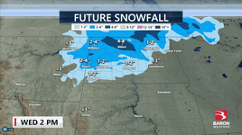
Wednesday 10 am CDT: High snowfall totals have been verified across a large section of North Dakota, where more than a foot has already fallen. The Baron future snowfall model shows an additional 4 to 8 inches may fall across many of the same areas before the storm exits on Thursday.
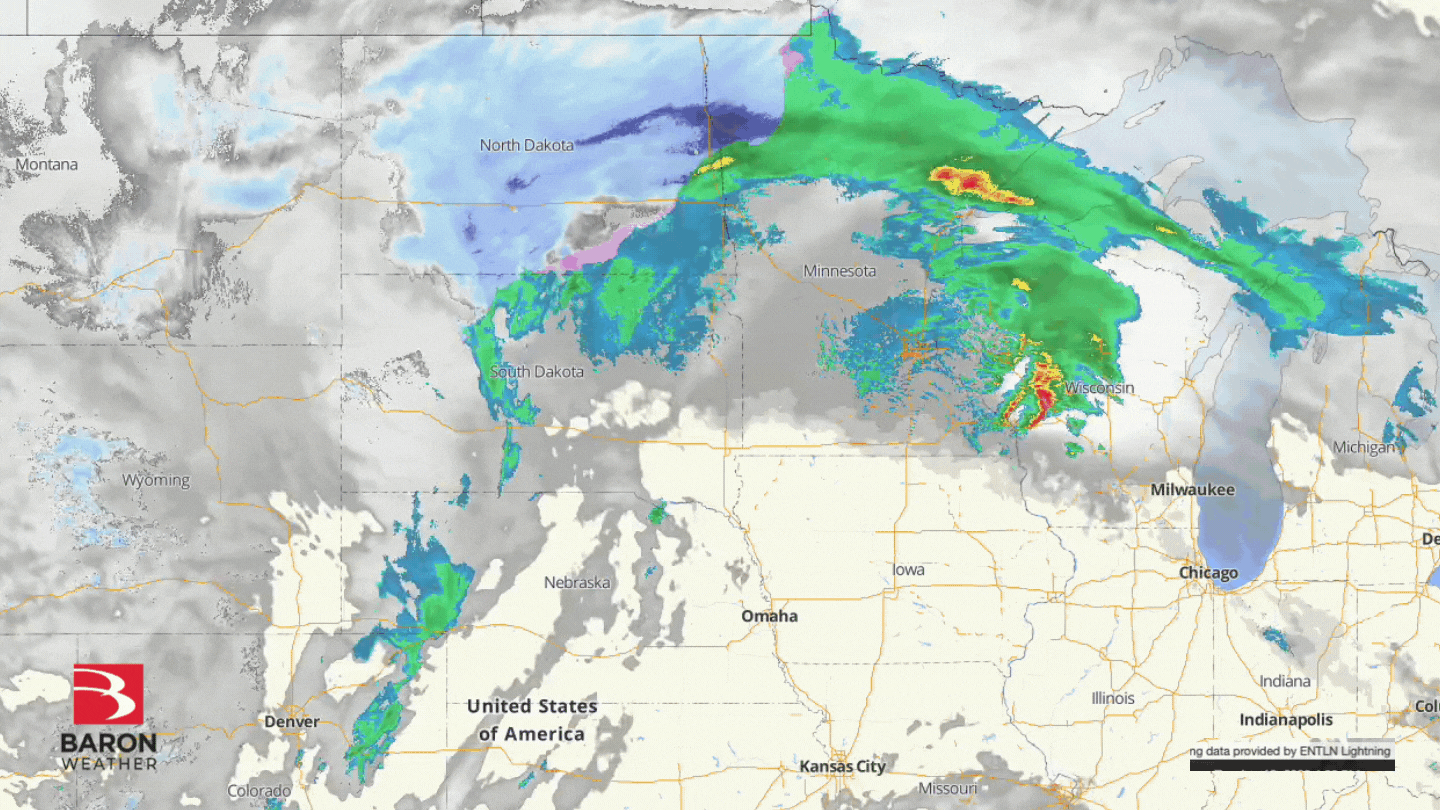
Tuesday 8 pm CDT: Thunderstorms blossomed over Iowa and Kansas Tuesday evening, with some cells becoming severe in less than an hour after forming. Meanwhile, blizzard conditions were noted only 200 miles to the northwest of the thunderstorms across central and eastern North Dakota.
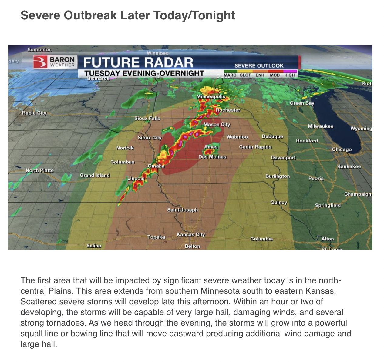
Tuesday 10 am CDT: Baron Lead Forecaster Kevin Nugent informed Baron partners of the increasing severe weather risk in parts of Iowa.
"Within an hour or two of developing, the storms will be capable of very large hail, damaging winds, and several strong tornadoes," he wrote in his daily email briefing.
Kevin also confirmed with staff that the trend noted Monday with the questionable southern extent of the severe risk is likely "coming to fruition."
It was also pointed out that the extreme snowfall totals the exclusive Baron model was putting out for North Dakota are becoming increasingly likely.
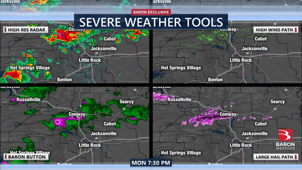
Monday 10 pm CDT: A Tornado Emergency was declared on the north side of Little Rock, where a "large, extremely dangerous tornado" was observed at the Little Rock Air Force Base. This tweet thread also explains that high levels of wind shear and a high probability of hail were noted on Baron's exclusive severe weather tools.
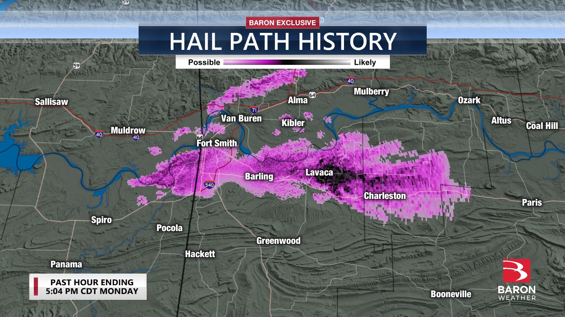
Monday 6 pm CDT: A complex of severe thunderstorms moved across portions of western Arkansas late Monday afternoon, where golf ball to baseball size hail was reported. The radar signatures also confirmed a tornado near Bloomer, AR.
The original story, which includes an overview of the event posted Monday morning, continues below this line.
Meteorologist and Graphic Artist Joshua Rivas briefed Baron staff on the event early Monday morning, referring first to the storm's scope of impact.
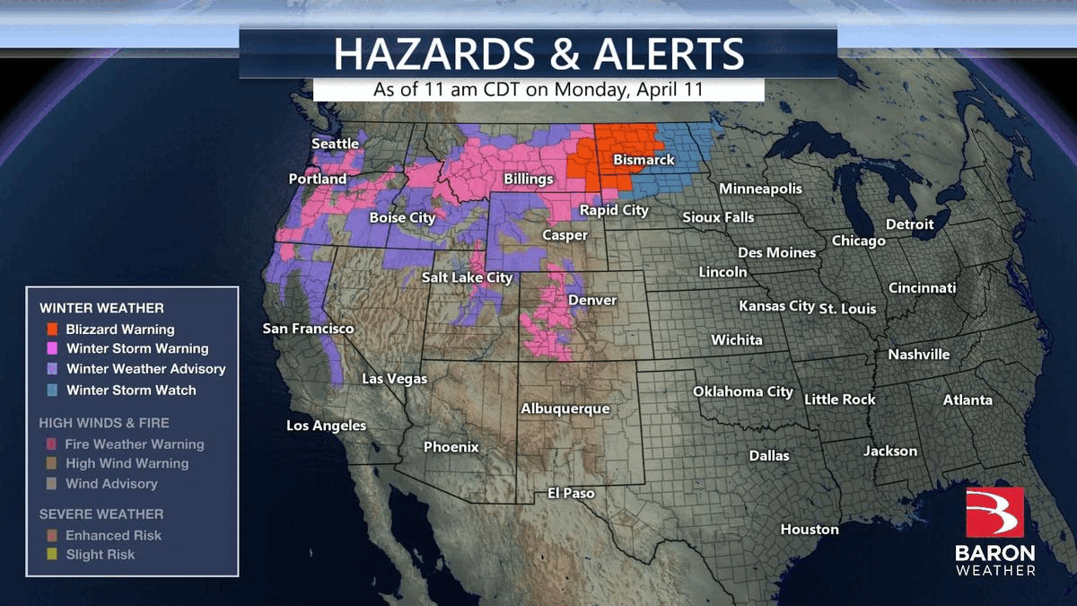
“You can really tell how big of a storm system this is just by looking at the number of watches and warnings issued by the National Weather Service already,” he said. “They stretch from the Canadian border to Texas, as far west as California, then as far east as the Ohio Valley.!”
Forecasters have been highlighting the potential for a significant weather event to unfold for several days, and public safety officials have been watching model simulations closely.
Severe Storm Potential
Confidence among forecasters was high for several days that a multi-day severe weather event would occur Monday through Wednesday from the Southern Plains to the Midwest. However, the extent and severity of the storms were uncertain leading up to the event due to concerns about thunderstorm coverage to the south and the extent of storm energy to the north.
Joshua also mentioned this in his briefing Monday morning, expressing his curiosity about the Baron model showing a large gap in storm activity.
"The presence of thunderstorms across the Gulf Coast region could limit the instability parameters farther north by interrupting the transport of necessary ingredients for storm energy. This is shown well by our Baron model across the Kansas and Oklahoma regions."
At the time of this post, a large area of the Central Plains was placed under an "enhanced risk" (level 3 out of 5) of severe storms Tuesday, but no higher risk levels had been drawn.
Extreme Fire Danger
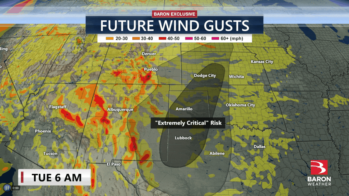
The high winds fueling the potential for severe weather ahead of the storm system have prompted the National Weather Service to issue Fire Weather Warnings from southern Arizona to Nebraska, with portions of Kansas and the Texas and Oklahoma panhandles under an “extreme” risk Tuesday.
In Baron Weather’s daily email briefing on Monday, Senior Meteorologist Kevin Nugent informed clients when the highest wildfire danger would occur.
“Winds will be the strongest during the afternoon hours, with many locations experiencing gusts of 40 to 60 mph,” he wrote. The winds will be combined with low humidity and occur “for several days”, he added.
Blizzard Conditions Possible
The winter side of the powerful low-pressure system could be just as extreme as the severe thunderstorms and high fire danger. Baron’s exclusive forecast model suggests more than a foot of snow will fall across large areas of Oregon, Montana and North Dakota through Wednesday. The model was also consistent in predicting extreme snowfall accumulations of over 18" in central North Dakota.
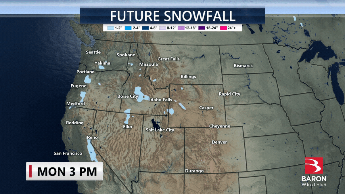
In addition to the heavy amounts of snow, strong winds across portions of North Dakota could lead to blizzard conditions and considerable drifting, where a Blizzard Warning is in effect.
Experienced, degreed meteorologists staff Baron Weather’s forecast services division with access to the highest-quality weather data. The products mentioned in this story are available to developers through the Baron Weather API or media professionals through the Lynx platform. Emergency response personnel can also customize products and views unique to their circumstance in mapping systems like ArcGIS or the Baron Threat Net web and mobile application.
