An "extremely active" hurricane season is expected this year, according to experts from Colorado State University (CSU). Record-warm ocean temperatures and a favorable upper-level wind pattern are the primary factors in this year's forecast for the tropical Atlantic basin.
| Forecast | Average | |
| Tropical Storms | 23 | 14 |
| Hurricanes | 11 | 7 |
| Major Hurricanes | 5 | 3 |
Senior Research Scientist Dr. Phil Klotzbach presented his team's first outlook Thursday morning at the National Tropical Weather Conference. He expressed "above-normal" confidence in predicting 23 tropical storms, 11 hurricanes, and 5 major hurricanes with 115 mph or greater winds. The 30-year averages for these numbers are 14, 7, and 3, respectively.
According to CSU's outlook, there is also a 62% chance of a major hurricane landfall in the United States, which is significantly higher than normal (43%). This is the first year CSU's team has incorporated regional meteorological factors into landfall probabilities, which yield a 34% chance the East Coast and Florida peninsula will get hit by a major hurricane and a 42% chance from the Florida panhandle to Texas.
Factors Aligning for a Hyperactive Season
Nearly all credible indicators of how active a hurricane season may be point to well-above-normal activity this year. The anticipated rapid transition from El Niño to La Niña leads the list, which can produce a more hurricane-favorable upper-level environment over the Caribbean and Western Atlantic.
A La Niña is a cyclical downturn in Pacific Ocean temperatures (compared to normal), which correlates to lighter upper-level winds over the primary formation regions in the Atlantic. NOAA's Climate Prediction Center says there is a 62% chance of this occurring by August and a near-zero chance that El Niño (La Niña's opposite) will continue into this year's hurricane season, further removing any inhibiting factors to tropical cyclone formation.
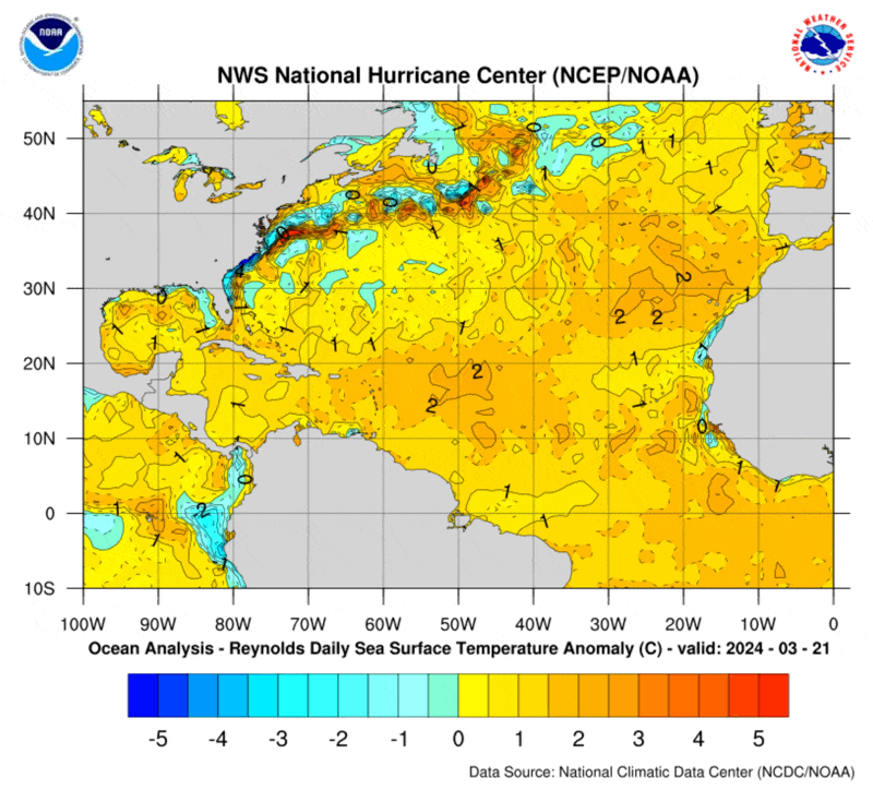
Hurricanes thrive on warm water, and plenty of it is already available. As of April 4, sea surface temperatures were more than 2°C above normal across the North Atlantic. These anomalies are the highest ever recorded, and they have been consistently at record levels for over a year, dating back to March 2023.
Global sea surface temperatures are also very warm, partly due to the current (but waning) El Niño.
Other factors that predict seasonal tropical activity include analog years with similar atmospheric patterns and the cyclical displacement of the Intertropical Convergence Zone (ITCZ). This region of instability and lift over the equatorial waters often triggers hurricane formation, where clusters of thunderstorms organize into an area of lower pressure. Forecast models indicate this year's ITCZ will be in a positive phase, meaning it's more likely to extend north into the prime formation zone of tropical activity over the central Atlantic.
Klotzbach and his team have extensively researched the correlation of these factors and concluded a 4 to 1 increase in tropical activity when all of these factors are present. He was even cautious in saying that his team's forecast numbers were "below all model guidance" for this year's season. His only reservation was that predictability and skill are much lower in early April than future release dates of his forecast, which will occur in early June and early August ahead of the traditional peak in seasonal activity.
Preparation is Key, Regardless of the Forecast
It only takes one storm to make it a bad hurricane season for your business or organization. And it's never too early to craft your hurricane business continuity plan, which should include smarter weather data and experts who know how to use it. The resources shared below can be a great starting point for your team.
The next hurricane to respond to is not a matter of if but when. Focusing less on a 6-month forecast and more on impact-specific vulnerabilities can better position your resources for the unexpected.
Hurricanes are complex, and the logistics of loss avoidance, mitigation, and response are even more complicated. Tracking a cone of uncertainty and waiting on a warning often doesn't cut it. Investments in weather monitoring tools such as historical analysis of weather perils or near-term forecasts can enable you to track a storm's growth or decay closer to landfall accurately. Knowing when to pull the trigger on a response requires precise data, actionable insights, and expert analysis.
