A multi-day severe weather outbreak swept through the Ohio Valley and Mid-South in early April 2025, marking one of the year’s most intense and prolonged extreme weather events.
Tornadoes. Flash flooding. Damaging winds. Large hail. For five days straight.
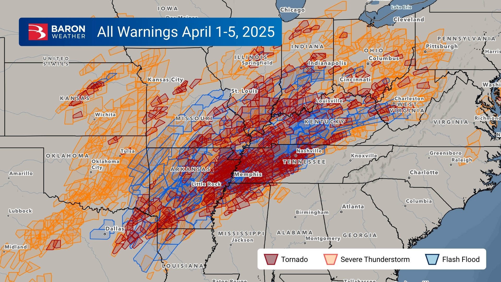
Over 60 million people were under a tornado, severe, or flash flood warning at some point on April 1-5. And 8.6 million were alerted for all three warnings during the five-day event.
For emergency managers and public safety officials, this wasn’t just a typical spring storm—it was a high-impact event with evolving conditions and compounding threats over several days.
Communities saw nearly a week of severe weather activity, with some areas experiencing rainfall totals between 6 and 15 inches. This led to widespread flooding, and river systems, like the Mississippi River, were still under flood warnings more than a month later. With constant data and shifting hazards, emergency managers were asking the same urgent questions: What do we need to focus on? When will it hit? And where?
Decision Support in Repetitive Events
For emergency managers, the challenge isn’t just tracking one storm - it’s staying ahead of evolving threats over multiple days, with shifting timing and locations. This April outbreak tested that capability. Officials needed to know:
- What is the threat today: Tornadoes, hail, flooding, or all three?
- What is the potential impact of that threat: How does this truly impact a community? What's really at the heart of what you're planning for?
- Where is it expected: Can we get this down to county or municipal-level detail?
- When will it hit: Can we narrow it from a vague afternoon window to 4–8 p.m.?
- How confident is the forecast: Should the EOC fully activate, or prepare in standby mode?
Baron products help simplify this complexity with platform-specific support:
- Baron Threat Net: Visualize and monitor storms with interactive weather data, enabling you to track their progression and make proactive decisions to mitigate potential risks.
- Weather Logic: All-in-one analysis tool and threshold-based alerting to pinpoint risks that matter most to your community and operations.
- ArcGIS Layers: Seamlessly integrate Baron’s severe weather layers into existing Esri platforms for situational decision-making tied to infrastructure and assets.
Case Study: Overnight Tornadoes in Selmer and Hardeman County
Radar imagery from the early hours of April 3 showed a well-defined hook echo over McNairy County, TN, with a tornado touching down near Selmer just after midnight. The EF-3 tornado remained on the ground for over 30 minutes, causing five fatalities and extensive structural damage. Less than an hour later, another EF-3 tornado touched down in Marshall County, MS, and carved a 40-mile path into Hardeman County, TN—killing two and injuring two more.
And the storms didn’t stop there. Additional hail, flash flooding, and wind events impacted these same areas into the morning hours, making response efforts even more dangerous. For emergency teams on the ground, the real-time guidance provided by Baron’s Storm Tracks, Twisting Storm Alert, and Flash Flood Risk tools helped prioritize life safety amid rapidly changing conditions.
Clarity in Complexity: Tools That Support Public Safety
A multi-day outbreak like this pushes decision-makers to the maximum. When there's not just one storm to plan for, but six consecutive days of threats, it becomes increasingly difficult to break down what matters most. That’s where Baron’s integrated suite of products—Baron Threat Net, Weather Logic, and ArcGIS weather layers—becomes invaluable.
Whether you're in an Emergency Operations Center, in the field, or part of a response team, Baron gives you actionable insights across the following key weather threats:
Flash Flooding
Baron’s Flash Flood Risk tool uses real-time radar and model data to pinpoint areas where rainfall is rapidly accumulating or expected. This gives emergency managers the ability to pre-position barricades, alert swiftwater rescue teams, and issue localized public warnings—especially when storms repeatedly impact the same communities.
Damaging Winds
Baron’s Damaging Wind Path product, based on shear rate, highlights areas of strong wind within severe storms. This real-time insight helps emergency teams anticipate power outages, structural damage, and transportation hazards, allowing for earlier resource staging and more focused risk communication.
Large Hail
With Baron’s Hail Swath and Hail Track tools, users can see where large hail has already fallen and where it’s likely to occur next. This is crucial for protecting crops, infrastructure, and vehicles, and for guiding post-storm recovery efforts like insurance assessment and utility inspections.
Tornadoes
During the overnight tornadoes near Selmer and Hardeman County, Baron’s Storm Tracks and Twisting Storm Alert provided early, precise insights into storm paths and rotation intensity. These tools are triggered by tornadic signatures detected within storms, providing emergency responders with critical lead time to activate safety protocols and issue timely public warnings.
Forecast Support
Ahead of the outbreak, Baron’s high-resolution model, featuring the 3km Updraft Helicity, identified potential tracks for rotating storms. In this case, the model’s forecasted paths aligned closely with where the tornadoes ultimately formed, giving emergency planners a valuable window for early decision-making and resource coordination.
Final Thoughts
In events where every hour and every decision matters, Baron gives public safety officials and emergency managers the clarity they need to act. Whether you’re tracking a tornado, deploying resources before a flood, or deciding when to open a shelter, Baron provides data-driven confidence across every platform you use.
Staying ahead of severe weather takes more than awareness. With Baron’s trusted tools, overwhelming data becomes clear, localized guidance you can act on.
