Winter weather brings more than snow accumulation maps. Ice, wind, extreme cold, and timing all shape how a storm affects people, infrastructure, and operations. Impacts can vary widely within the same system — from power outages and hazardous roads to airport delays or minimal disruption just a few miles away.
Understanding how winter hazards interact and where their impacts differ helps teams plan, communicate, and respond more effectively. Winter storms often feature tight gradients and subtle shifts that lead to big consequences, which is why relying on a single dataset rarely tells the full story. Combining current conditions with targeted forecasting guidance provides the context needed to identify uncertainty, reinforce confidence, and adjust plans as conditions evolve.
How Timing Shapes Impacts
Winter impacts are often driven by how quickly conditions change, not just how much precipitation falls. Rapid snowfall or ice accumulation can overwhelm road treatment efforts, reduce visibility, and quickly degrade travel conditions. Slower, longer-duration events may still pose challenges but often require a different approach to preparation and messaging.
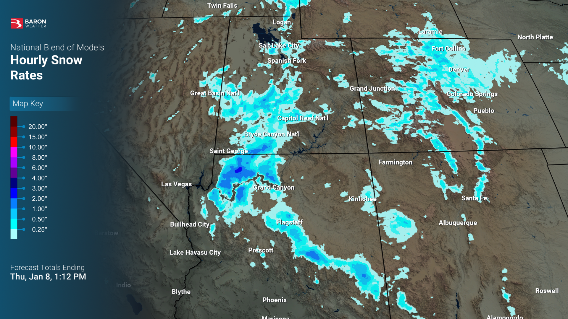
Hourly perspectives — especially early in an event — help identify when impacts will peak, allowing teams to focus resources, staffing, and communication during the most critical windows. Understanding timing helps decision-makers plan for when conditions will be most disruptive, not just what is expected.
Not All Ice Is the Same
Ice accumulation depends heavily on what it’s accumulating on. Horizontal icing indices are useful for understanding surface-level hazards, such as road and walkway conditions that affect travel and safety, while radial icing indices help identify where elevated, three-dimensional structures like trees and power lines may be most vulnerable. Viewing ice from both surface-level and infrastructure-focused perspectives helps explain why impacts can differ dramatically across short distances.


Frozen precipitation type matters as well. Freezing rain is more likely to load trees and power lines, increasing outage risk, while sleet tends to accumulate on roadways, significantly affecting driving conditions. Clearly distinguishing between sleet and freezing rain helps set more accurate expectations and supports better preparedness during mixed-precipitation events.
Road Conditions Matter as Much as What’s Falling
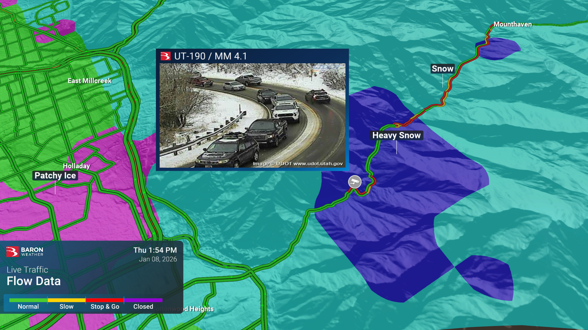
Winter travel impacts depend on surface conditions, not just precipitation. Road temperatures, pavement state, and drying processes all influence how winter weather affects mobility. Snow or ice falling on a warm surface may have a limited impact, while similar conditions on colder pavement can quickly become hazardous. Incorporating road temperature and road condition insights connects atmospheric conditions directly to real-world travel outcomes.


When paired with traffic and camera views, these perspectives help provide a clearer picture of evolving conditions on the ground.
High-Impact Winter Events
Certain winter patterns consistently lead to higher-end impacts. Blizzard conditions, lake-effect snow, significant icing, and Arctic air intrusions often combine multiple hazards at once — including wind, visibility loss, and extreme cold. These setups can evolve quickly and produce compounding impacts that affect transportation, utilities, and public safety.


Identifying these scenarios early allows teams to shift focus from totals to outcomes and prepare for rapidly changing conditions.
Systems at Scale
Winter storms often trigger cascading impacts that extend beyond the storm itself. Power outages, transportation disruptions, and operational slowdowns can persist long after precipitation ends. Assessing where these risks are highest — and how they overlap — adds valuable situational awareness. Large winter systems can also disrupt operations across wide regions, with airport delays and closures extending impacts far beyond a single forecast area.


Viewing winter impacts at scale helps place local conditions into a broader regional or national context.
Winter Success Starts Now
Effective winter forecasting requires understanding where impacts occur, when they peak, and how different hazards interact.
With the right mix of data, perspective, and context, teams across emergency management, transportation, utilities, and operations can make clearer, more confident decisions. Talk with a Baron expert to explore winter-focused data, tools, and workflows designed to support planning, response, and communication throughout the season.
