The 2026 Special Olympics USA Games gave nearly 3,000 athletes the opportunity to compete, celebrate their accomplishments, and showcase their hard work. Behind each athlete was a team of coaches, family members, volunteers, and supporters helping make those moments possible.
Behind them was another network working largely out of sight. Event organizers, emergency personnel, technology partners, logistics and transportation teams, and data providers coordinated across multiple venues to help keep everyone safe and informed.
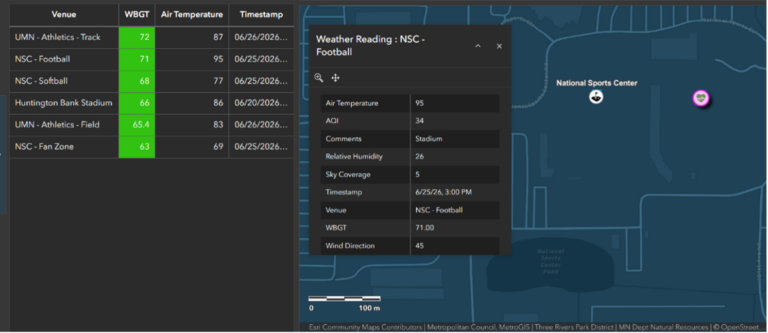
Baron Weather was part of that network. Working alongside Esri and other partners, Baron provided real-time weather data and lightning detections that were integrated into ArcGIS, helping event organizers monitor evolving conditions within the same shared operational view used across the Games.
Connecting Weather to the Games
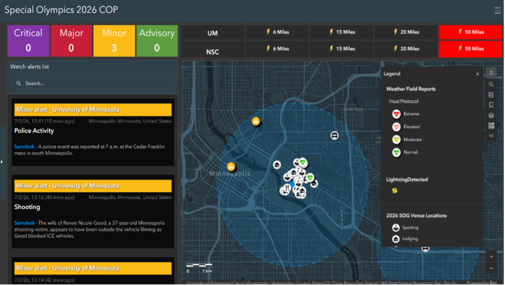
Coordinating a large event requires many teams to work toward the same goal, even when their responsibilities look very different. As part of Esri’s GIS for Good initiative, Esri worked with the Special Olympics USA Games emergency and consequence management team to bring information from across the event into ArcGIS. Transportation updates, field observations, threat intelligence, and weather data could all be viewed within a common operating picture.
Weather can quickly affect an outdoor event. Lightning, rainfall, heat, and other changing conditions can influence competition schedules, transportation, staffing, crowd movement, and decisions at individual venues. But monitoring the weather is only part of the challenge. Event organizers also need to understand where conditions are developing and which locations or activities may be affected.
“The real value wasn’t simply having more information; it was seeing that information in context and understanding how one developing condition could affect a venue, a transportation route, a competition schedule, or the people moving throughout the Games,” Speranza said.
Baron’s real-time weather data and lightning detections added weather information to the Games’ operational view in ArcGIS. Instead of existing in a separate weather platform, the data could be viewed alongside the other information the operations team was already monitoring.
“With ArcGIS Velocity’s native connector to Baron Weather, we were able to easily establish a connection to Baron’s lightning data feed, enabling real-time monitoring of lightning strikes within configurable distances of sporting venues and seamless visualization within the Common Operating Picture (COP),” said Colin Cate, Senior Solution Engineer, Public Safety at Esri. “With this capability in place, USA Games officials could make informed, real-time decisions regarding player safety, including delaying or suspending activities, initiating shelter-in-place procedures, and coordinating incident response efforts based on evolving weather conditions.”
Working from the Same Picture
With Baron’s weather intelligence, Samdesk’s threat intelligence, field observations from university students, and transportation updates brought together in ArcGIS, event leaders gained a shared foundation for communication and coordination across venues.
“This provided a shared operational view for event staff and public safety personnel, helping ensure timely, consistent, and data-driven decision-making throughout the Games,” Cate said.
“That common operating picture helped leaders connect the dots, coordinate across teams and venues, and move from monitoring conditions to understanding their operational implications,” Speranza added.
Keeping the Athletes in the Spotlight
The athletes and families attending the Games may never have seen the dashboards or data feeds supporting event operations. They did not need to.
“Ultimately, all of that behind-the-scenes coordination served one purpose: creating an environment where athletes and their families could focus on the experience, the competition, and the celebration at the heart of the Games,” Speranza said.
Baron’s contribution was part of a coordinated effort in which each team brought different expertise and information. Together, they helped create an environment in which the athletes could remain at the center of the Games.
“Having worked in emergency management, I understand what it means for the public-facing side of an event to run smoothly while a lot of coordination happens out of view. Supporting the Special Olympics USA Games this way, helping keep athletes and families at the center while our data quietly did its job, is exactly the kind of impact we hope to have,” said Jessica Stumpf, Public Safety Solution Engineer at Baron Weather.
Weather Intelligence for Events and Venues
The same approach can support other events operating across large sites, outdoor spaces, or multiple venues. Weather does not exist separately from logistics, schedules, transportation, or safety. It can affect all of them, often with little time to respond.
Bringing real-time weather data into the systems an organization already uses allows teams to evaluate conditions alongside the people, locations, and activities they need to protect. It transforms weather from another feed to monitor into actionable operational context.
Behind the competition and celebration at the 2026 Special Olympics USA Games was a network of people, technology, and information working together. Baron is proud that its weather intelligence was part of the effort supporting those unforgettable moments.
Learn how Baron’s ArcGIS-ready weather data brings real-time weather intelligence into the systems your team already uses. Explore Baron’s ArcGIS Weather Layers or request a demo to see how it can support your operations.