For most electric utilities, ArcGIS is far more than a mapping platform.
It's the system of record for infrastructure, assets, service territories, and operational workflows. It serves as the foundation of a utility's digital twin and supports decision-making across grid operations, reliability, outage response, wildfire mitigation, and field operations.
Utilities have invested significant time and resources in building and maintaining this environment. As a result, ArcGIS has become the place where critical operational decisions are made.
Yet weather information is often accessed through separate websites, applications, or public data feeds.
If ArcGIS is where operational decisions are made, shouldn't weather intelligence be there too?
The Value of Weather Inside ArcGIS
Weather impacts nearly every aspect of utility operations.
Severe storms can threaten transmission and distribution infrastructure. Lightning can impact crew safety. High winds can increase outage potential. Wildfire conditions can influence mitigation efforts, PSPS planning, and operational decisions.
To understand those risks, utilities need weather information in the same environment as their assets, service territories, and operational data.
Weather intelligence becomes even more valuable when it's paired with ground-truth observations from utility-owned weather monitoring networks. Together, observations and forecasts provide the context teams need to understand both current conditions and future risk.
That's where the partnership between Baron Weather and Western Weather Group comes in.
Through the partnership, utilities can combine Western Weather Group station observations with Baron's ArcGIS-native weather intelligence, bringing current conditions, future risk, and operational context into a single operational environment.
Western Weather Group provides the asset-level observations utilities rely on to understand what's happening right now. Baron Weather provides the forecasts, radar, lightning, and weather intelligence that help teams understand what's coming next.
The result is a more complete operational picture, one that helps utilities make more informed decisions before, during, and after high-impact weather events.
Making ArcGIS Work Smarter
When weather intelligence is integrated directly into ArcGIS, teams gain the context they need without changing the way they work.
Through more than 60 ArcGIS weather map and feature services, Baron Weather brings radar, forecasts, lightning, watches and warnings, and other weather intelligence directly into the maps, dashboards, and applications utility teams already use every day.
A utility may overlay lightning data with active work locations to support crew safety, compare forecast wind speeds against transmission and distribution infrastructure, or visualize radar and forecast precipitation alongside outage data during storm response operations.
These insights can help teams make more informed decisions around crew deployment, storm preparation, wildfire mitigation, and grid operations.
GIS teams can combine weather, assets, outages, and operational data into a single view. Grid operations teams can monitor evolving conditions across their service territory, while utility meteorologists and reliability teams gain greater visibility into weather threats affecting critical infrastructure.
The map shifts from "Here's our infrastructure" to "Here's our infrastructure and the weather risks affecting it."
The weather comes to the workflow rather than forcing the workflow to come to the weather.
A More Complete Operational Picture
Many utilities already operate weather monitoring networks across their service territories to better understand local conditions and support operational decision-making.
Western Weather Group has been at the forefront of that effort, helping utilities deploy and maintain utility-grade weather monitoring networks built specifically for critical infrastructure operations. Today, the company supports more than 8,000 weather stations and 25,000 sensors across 35+ states.
These observations provide critical, asset-level data.
While forecast models and gridded weather analysis provide broad coverage, station observations show what is actually happening on the utility infrastructure. They help validate forecasts, identify localized conditions, and create a defensible record of weather conditions during significant operational events.
Through the partnership between Baron Weather and Western Weather Group, those observations become part of the broader operational picture utilities rely on inside ArcGIS.
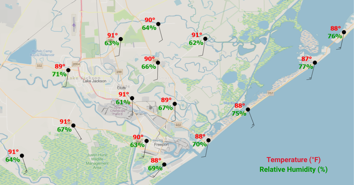
For example, a utility may use Western Weather Group station observations to monitor real-time wind conditions in a wildfire-prone area while simultaneously viewing Baron forecast wind data, lightning activity, radar, and weather alerts within ArcGIS.
Data Gallery Title
.png?v=1d445f6e6791)




Together, those observations and forecasts provide a more complete view of current and future conditions. Teams can validate forecasts against real-world observations, identify localized weather impacts, and better understand how evolving conditions may affect infrastructure, crews, and operations.
Instead of moving between multiple systems, GIS teams can visualize utility-owned observations alongside weather intelligence within a single operational environment.
The result is greater situational awareness, better context for decision-making, and a more complete operational picture.
Reliability When It Matters Most
Utility decisions are only as good as the information behind them.
Whether supporting wildfire mitigation efforts, storm response operations, crew safety, or grid reliability, utilities need weather information they can trust.
Western Weather Group's utility-grade monitoring networks provide calibrated, ground-truth observations from the locations utilities care about most. Baron Weather complements those observations with quality-controlled weather intelligence and proprietary products such as high-resolution lightning data and Storm Intel, including the Baron Tornado Index (BTI).
Together, trusted observations and trusted weather intelligence help utilities move beyond simply viewing weather conditions and toward making more confident operational decisions.
Getting More Value from Your ArcGIS Investment
Utilities have already invested heavily in ArcGIS.
The opportunity isn't replacing that investment. It's enhancing it.
By combining ArcGIS-native weather intelligence from Baron Weather with utility-owned observations from Western Weather Group, organizations can create a more complete view of weather risk and support better decisions before, during, and after high-impact weather events.
Because when weather impacts the grid, weather intelligence is most valuable where operational decisions are made.
Contact Western Weather Group to learn more about integrating utility-owned weather station observations into ArcGIS or explore Baron Weather's ArcGIS Weather Layers to see how weather intelligence can be incorporated directly into your existing GIS workflows.