Early warning systems are built to answer one question: will people know dangerous weather is coming in time to protect lives and property?
The first signs can appear months before a storm forms. On November 12, 2026, NOAA’s Climate Prediction Center reported that sea surface temperatures in the eastern equatorial Pacific were running more than 4°C above normal, with the warmth spreading farther west. Forecasters gave a greater than 79% chance of a strong-to-very-strong El Niño lasting through early 2027, and about a 60% chance it would become the strongest on record since 1950 (NOAA CPC).
In September, the World Meteorological Organization put the chance of El Niño lasting through February 2027 at nearly 100% (WMO).
That number doesn't tell anyone which town will flood or which substation will lose power this winter. What it does is shift the odds months in advance, before a single storm has formed. That makes it the first link in a chain that runs all the way to the moment someone acts on a warning.
So, what is an early warning system? UN member states agreed on a definition in 2017. An early warning system is an integrated set of monitoring, forecasting, risk assessment, communication, and preparedness that enables people, governments, and businesses to act before a hazard arrives (Multi-hazard Early Warning Systems: A Checklist).
Back in 2006, a UN team outlined four elements every early warning system needs (Developing Early Warning Systems: A Checklist):
- Risk knowledge: understanding which hazards an area faces and who is exposed.
- Monitoring and forecasting: observing the atmosphere and predicting what it will do.
- Communication: getting warnings to people in a form they understand and can act on.
- Response capability: having plans and people in place to act when a warning arrives.
A UN global survey published the same year made the point that matters most: if any one of those elements fails, the whole system can fail (Global Survey of Early Warning Systems).
Risk knowledge starts months out, with seasonal patterns like El Niño. Monitoring and forecasting then narrow the window: days to hours out for floods, minutes out for radar. Communication and response decide whether that lead time is used.
Interest in the question is higher than usual, heading into 2027. After all, 2027 is the year the UN set as its goal for covering everyone on Earth with early warning systems. Each link in the chain works on a different lead time, from months for a seasonal signal to minutes for a radar warning. But that lead time only helps if the last two steps also happen: the warning reaches people, and someone acts on it.
What Can El Niño Tell Forecasters Months Ahead?
Risk knowledge, the first element of an early warning system, begins months in advance with seasonal climate patterns such as El Niño, which can shift weather risks before a storm forms. El Niño is a warming of surface waters across the central and eastern equatorial Pacific, paired with weaker trade winds. Because the tropical Pacific is so large, warming changes where storms track and where rain falls far beyond the Pacific itself.
Its effects reach far beyond the Pacific. WMO notes that El Niño typically brings more rain to parts of southern South America, the southern United States, the Horn of Africa, and Central Asia, and drier conditions to Central America, northern South America, the Caribbean, Australia, Indonesia, and parts of southern Asia (WMO). Those are tendencies, not promises. WMO also cautions that the strength of an El Niño does not directly translate into the magnitude of its impacts in any one region (WMO).
That is what makes seasonal outlooks useful. They don't tell a national weather service or disaster agency what will happen on a given day. They show which risks warrant more planning this season: where to pre-position supplies, which communities to prepare for, and which weeks to watch closely once shorter-range forecasts become available.
For U.S. readers, the Baron Weather El Niño Tracker compares the ten strongest El Niño winters since 1950 with all other winters, county by county.
The current event will run its course, but the lesson is carried over. The earliest warning is a change in odds, and organizations that plan around those odds start the season with an advantage.
As the season unfolds, the window narrows from months to days. In regions where El Niño raises the odds of heavy rain, flooding is often where those odds turn into real damage.
How Far Ahead Can Floods Be Forecasted?
Monitoring and forecasting, the second element, depends on the hazard. For example, river floods can often be forecast days in advance, while flash floods may give only hours of warning. The difference is how quickly the water arrives. A river flood builds as rain collects across a whole basin and drains downstream, so forecasters can track the water as it moves and issue crest forecasts days ahead.
Flash floods are different. The water rises within hours of heavy rain, sometimes within minutes. The U.S. National Weather Service, for example, defines a flash flood as one that begins within six hours of the rain, and often within three (NWS). Steep terrain, saturated soil, and dense urban areas all shorten the time between rainfall and rising water.
That gap is why flood risk needs two kinds of forecasting. Days out, the question is how much rain is coming and where it will collect. Hours out, the question is how quickly the ground and drainage can absorb what is falling right now, and that answer depends on observing rainfall in real time.
For countries building that second kind of capacity, WMO's Flash Flood Guidance System, developed with partners including the U.S. National Weather Service, provides flash flood guidance and covers more than 40% of the world's population across more than 72 countries as of 2022 (WMO).
Baron's Flood Finder is built for that second kind of forecasting. It pairs a physics-trained AI model with weather inputs to estimate flood depth, flow speed, and flow direction at the street and basin levels during a live event, with guidance in 5 to 10 minutes. It can run on Baron's forecasts, a country's own radar, a regional model, or all three.
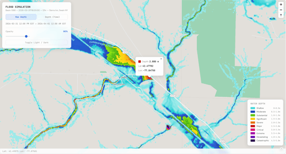 Baron Flood Finder Simulation
For a national weather service or disaster agency, the practical step is to know which type of flooding each community faces. Towns along large rivers can plan around crest forecasts. Communities in steep or low-lying areas need warnings tied to what the rain is doing in real time. That real-time view comes from radar.
Once a Storm Forms, How Does Radar Help With Warnings?
Radar handles the shortest-range part of monitoring and forecasting. It shows what a storm is doing right now, while a forecast estimates what it will do. It measures where rain and hail are falling, how hard they are falling, which way a storm is moving, and whether the winds inside it are rotating. Dual-polarization radar adds detail on the size and shape of what the beam hits, which helps separate heavy rain from hail and can reveal debris lofted by a tornado.
That is why radar carries the most weight in the final minutes before severe weather arrives. It is also where coverage matters most. A radar beam travels in a straight line while the Earth curves away beneath it, so the farther a storm is from the radar, the higher above the ground the beam passes. Far from a radar site, the lowest part of a storm, where tornadoes and damaging winds form, can sit below the beam entirely. Radars placed closer to the people and assets they protect fill in that low-level view.
Why Transmitter Technology is Part of the Conversation
Most weather radars in service today generate their signal with a vacuum tube, either a magnetron or a klystron. Solid-state radars use semiconductor amplifiers instead. They transmit at lower peak power over longer pulses and use a processing technique called pulse compression to keep fine resolution. Each design has trade-offs, and the right choice depends on the radar's band, the area it needs to cover, and how it will be operated and maintained.
Those choices matter most where observation networks are thinnest. WMO reports significant data gaps, especially in Africa, where surface station density is far below global standards, and notes that many stations in Least Developed Countries and Small Island Developing States are not operational. Those gaps reduce forecast accuracy locally and globally (WMO). Closing them is a central part of the UN's Early Warnings for All work on monitoring and forecasting (WMO).
Baron recently added a solid-state option to its own radar line, Baron Fortress. The C-band version is available now, with an S-band version planned for 2027.
Seeing a storm is only half the job. Once radar shows the threat, it still has to become a warning that people hear, understand, and believe.
How Different Industries Turn Lead Time Into Avoided Cost
The economics look different depending on what you are protecting.
Emergency management: The decision is whether to warn, evacuate, and pre-position, usually on incomplete information and a short clock. Basin-level guidance narrows the uncertainty and widens the window people have to get out safely. The two Guadalupe events, a year apart, show how much that window can change the cost of a flood to a community.
Utilities and energy: Flood, wind, and ice damage to substations and distribution infrastructure is largely a pre-positioning problem. Knowing which assets sit inside the threat footprint hours ahead, rather than minutes, changes where crews stage, how long outages last, and what restoration costs are. It also keeps crews out of conditions they should not be driving into, which matters well beyond the balance sheet.
Transportation and logistics: Road closures, rail disruption, and bridge failures follow flash flooding with very little warning. Location-specific impact guidance supports proactive rerouting instead of reactive detours, and the savings show up in fuel, labor, and service-level performance rather than in property damage.
Insurance: Weather intelligence touches underwriting, catastrophe response, and claims. Radar-derived hail swaths, wind swaths, rainfall totals, and storm reports help teams identify likely impact areas before claims volume peaks, prioritize inspections, and validate reported conditions afterward. Our buyer's guide to evaluating weather intelligence for insurance covers what to look for across that lifecycle.
Agriculture and construction: The cost here is mostly labor and scheduling. Crews idled, pours ruined, harvest windows missed. Thresholds matter more than headline forecasts, because the call is usually whether to work today, not whether to evacuate.
National hydrological and meteorological services: The constraint is frequently infrastructure rather than expertise. Modeling that relies only on radar and forecast inputs can extend flood guidance into areas where building out a ground sensor network is not feasible within any near-term budget.
How Do Weather Warnings Reach the Public?
Weather warnings reach the public through broadcasters, phone alerts, websites, social media, and sirens. This is communication, the third element of an early warning system, and the one where many warnings break down. An accurate forecast is not the same as a warning people act on. To work, a warning must reach people in time, make sense to them, and convince them it applies to where they are. The 2006 checklist frames this as the difference between a technical system and a people-centered one: the warning has to be timely and understandable to those at risk, with guidance on what to do (Developing Early Warning Systems: A Checklist).
This is where meteorologists do work that no data feed can replace. During a hurricane, the threat encompasses multiple hazards at once: storm surge along the coast, inland wind, flooding rain, and tornadoes in the outer bands. Each one affects different neighborhoods at different hours. The meteorologist's job is to sort that into what matters to the viewer right now, present it clearly, and keep doing it for hours or days.
Indonesia’s national weather agency, BMKG, addresses this at the national level. The country spans more than 17,000 islands, so making a forecast feel local is a constant challenge. BMKG uses Baron Lynx to produce broadcast-style forecasts for its YouTube channel and to zoom in on individual islands, so viewers see conditions where they live. “We have many islands in Indonesia, and with Lynx, we can pop up the island to localize the forecast,” said Priscilla Deliana of BMKG’s production team (BMKG).
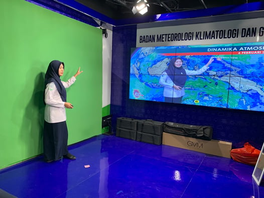 BMKG presenting in studio, using Baron Lynx.
Broadcast is one channel among several. Many national weather services now issue warnings using the Common Alerting Protocol, a standard format that allows a single warning to reach phones, broadcasters, websites, and sirens at once. WMO reports that adoption of the protocol has surged (WMO).
The lesson from storms like this is that communication is its own link in the chain, with its own failure points. A warning can be accurate and still fail if it arrives late, reaches the wrong audience, or is too hard to read when people are deciding whether to leave.
Who Acts on the Warning, and How Do They Know When?
Response is the fourth element of an early warning system, and it belongs to the people and organizations who act on the warning. Every earlier link ends with information. This one ends with a decision. For a family, that might mean leaving a coastal home or moving livestock to higher ground. For a disaster agency, it means opening shelters or moving supplies into place. For a utility or an airport, it means staging crews or adjusting operations before the weather arrives.
Organizations that respond well tend to have three things in place before the weather arrives:
Decisions made in advance: Who makes the call, what conditions trigger it, and what action follows? Deciding during the storm costs time that the warning was supposed to provide.
Alerts tied to those conditions: When a specific threshold is crossed at a specific location, the right people are automatically notified. Nobody has to watch a radar loop and decide whether it looks bad enough.
A review after each event: What triggered, what was late, and what should change before the next one.
This is also where weather awareness becomes an operational advantage. Two organizations can receive the same forecast and have very different outcomes. The difference is rarely the forecast. It is whether the warning was connected to an advance plan that led to better decisions.
That brings the chain back to where it started. A seasonal outlook, a flood forecast, and a radar scan are only as useful as the last link allows. When the response is planned, every warning upstream has somewhere to go.
Frequently Asked Questions
What is an early warning system? An integrated set of hazard monitoring, forecasting, risk assessment, communication, and preparedness that lets people, governments, and businesses act before a hazard arrives. UN member states agreed on that definition in 2017 (2017 checklist).
What are the elements of an early warning system? Risk knowledge, monitoring and forecasting, communication of warnings, and the capacity to respond. The framework was set out at the Third International Conference on Early Warning in 2006 and updated in a 2017 multi-hazard checklist (2017 checklist).
What is the Early Warnings for All Initiative? A UN initiative launched in 2022 with the goal of protecting everyone on Earth with multi-hazard early warning systems by the end of 2027 (WMO).
Does a strong El Niño guarantee drought or flooding? No. A strong event increases the likelihood of typical El Niño impacts, such as drier conditions in Indonesia and Australia or more rainfall in parts of southern South America. WMO notes that the strength of an event does not translate directly into the size of its impacts in any region (WMO).
What is the difference between a flash flood and a river flood? A river flood builds as water collects across a basin and flows downstream, so it can often be forecast days in advance. A flash flood can begin within six hours of heavy rain, and often within three, leaving far less time to act (NWS).
What is a solid-state weather radar? A radar that generates its signal with semiconductor amplifiers rather than a vacuum tube such as a magnetron or klystron. Solid-state radars transmit at lower peak power over longer pulses and rely on pulse compression and digital processing to keep fine resolution (Frasier and Facheris, Developments in Solid-State Weather Radar).
Sources
NOAA Climate Prediction Center, ENSO Diagnostic Discussion, November 12, 2026
WMO, El Niño/La Niña Update, August 2026
WMO, Prepare for El Niño
Developing Early Warning Systems: A Checklist, Third International Conference on Early Warning, 2006
Global Survey of Early Warning Systems, United Nations, 2006
Multi-hazard Early Warning Systems: A Checklist, 2017
WMO, Early Warnings for All in Focus: Hazard Monitoring and Forecasting
Down To Earth, on the Early Warnings for All launch and 2027 goal
WMO, Closing the gap in observations
WMO, Flash Flood Guidance System with Global Coverage
National Weather Service, Flash Flood definition
Frasier and Facheris, Developments in Solid-State Weather Radar, Advances in Weather Radar, 2023
_______________________________________________________________________________
Baron Weather is a global weather intelligence company serving broadcast media, enterprise organizations, and government agencies worldwide. Our solutions span the full spectrum of weather technology — from physical weather radar systems and proprietary weather modeling platforms to real-time data, analytics, and decision-support tools. Whether protecting on-air broadcasts, enabling operational decision-making for large enterprises, or supporting the forecast and warning missions of government agencies and meteorological services around the world, Baron brings together the depth of science and the precision of technology.